Tuscobia State Trail in Northern Wisconsin ". . . A Trail for All Time."
The trail crosses through four counties: Price County, Sawyer County, Washburn County and Barron County
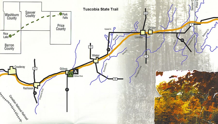
History, Development, and General Trail Information Wisconsin DNR owns the Tuscobia Trail which was used as railway from about 1900 to the 1940s for logging, farming, and service industries. Dismantling the railway began in about 1967. Citizen interest in developing the route as a historical and scenic trail increased and by 1968, the 74 mile trail began its life as the longest state trail presently in use. The trail crosses through four counties: Price County, Sawyer County, Washburn County and Barron County. Towns and the services available in each are bulleted below as is camping information. The Tuscobia is currently used for hiking, snowmobile, and ATVs. Skiing and cycling remain as future options. Visit the web site: www.toscobiatrail.com or call 1-800-762-7179 for a trail map.
From April 15 to November 15, the trail from Park Falls to just west of Birchwood is open to ATVs. The trail west of Birchwood to Rice Lake is closed to ATV use and is part of the 1000 mile Ice Age national Scenic Trail. (est.1958) One of eight national scenic walking/hiking trails, the Ice Age trail traces the edge of the most recent glacier moving through the area 75,000 – 10,000 years ago. There’s some interesting geography associated with the glaciers: Moraines, eskers, kettles. Learn more at: www.iceagetrail.org.
Wisconsin Elk It’s possible to see Elk on the Tuscobia trail. Elk were reintroduced into the Loretta/Draper area in the early 1990s. The best Elk viewing is along the Dead Horse Run ATV/Motorcycle Trail which links-up with the Tuscobia trail east of Loretta, near Log Creek. September and October, during the rut at dusk and dawn, are the best viewing times. Contact the Great Divide Ranger District at 715-762-5701 for more information and a map of the amazingly scenic Dead Horse Run Trail. Waterways
Here’s your chance to try out your ATV canoe carrier! There are lots of waterways along the Tuscobia Trail. Chetac Lake is 1920 acres with a maximum depth of 28’ and an average depth of 12-18 ft. There are a few resorts on the lake any of which would make a nice “base camp” from which to explore. The Chippewa River (near Ojibwa), the Flambeau River (near Park Falls), Butternut Creek, and the Brunet River cross the trail time and again. These rivers have a few low rapids which kayakers like. The rivers in the Birchwood area are known to be especially good for trout. Our experiences We had trouble finding the county park trail head in Park Falls and ended up parking on a side street and backtracking along the trail to find the park trail head. The map showed that we could access this trail head via County Highway 13, but we could not find a road in from that direction. If you want to begin from Park Falls, plan to access the trail via county road E. The mini town maps on the back of the trail map weren’t specific enough to include street names or all the crossroads. Look for the newer of the two water towers and you’ll know you’re near the trailhead.
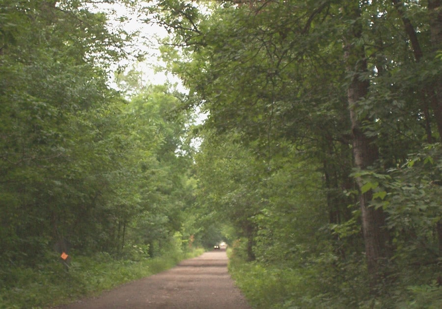
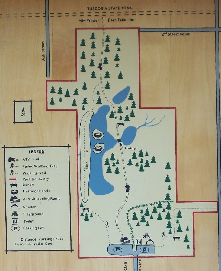
When we did find the trailhead, we were impressed by the large asphalt parking area. The restrooms were clean (flushing toilets!), there were grills available, and a play area for children with swings and climbing obstacles. There was also have a nice trail map board (see photo) and a soda machine. The majority of the riding base is gravel/sand, so there’s lots of dust. A few segments appeared to be crushed asphalt, which helped with the dust tremendously. This is an excellent run for a new or relatively inexperienced rider as it’s pretty flat and fairly straight. It’s also good for hot weather as it’s a faster ride. You could probably do the whole trail in a day but we got started late and so split it into two days: the first day from Park Falls to Ojibwa, the trail hugged the highway pretty closely. On the second day, from Ojibwa to Birchwood, the trail crossed some nice farmland and into a few forested stretches. Tuscobia Trail Map
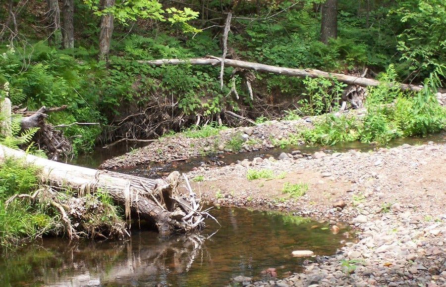
The map “looks” good until you try to use it. We wished it showed more of the connecting routes and trails. Another short trail not mentioned on the map was the Lyle Crawford Memorial trail. We lunched near a charming creek alongside giant ferns. See photo. A couple other trails adjoined the Tuscobia, but we didn’t have time to explore. Trail #27 was one, and Nine Mile Loop was another, neither was marked on our Tuscobia map. We saw about twelve other quads our first day out and at least 24 the second day. This may be because we went on Fri and Sat. of the Fourth of July weekend.
Trail Signage One of the nice things about the Tuscobia Trail is that they have signs warning of upcoming driveways. They also place stop signs for vehicular cross traffic at some of the driveway crossings, although it’s always a good idea to slow down.
Jim’s latest gadget Jim’s latest gadget is an extender to raise his rearview mirrors up about an inch. He was having trouble seeing over his big square box on the back rack and so had our local welding shop make this up for him. It’s a 1 inch nut and a threaded bolt which screws into the existing mirror mount. I have a box that slants down at the corners. I lose a little room, but can see just fine. We really like having mirrors. It saves on the neck--not having to turn around, and keeps us from being surprised by folks coming up behind us.
Towns, terrain and services available on the trail, East to West Park Falls : location of the Park Falls-Tuscobia Trailhead County Park. It has an ATV Loading ramp, gas, food, lodging, camping, retail, service. Just west of town is the Smith Lake campground.
Camping There is camping along the trail at Smith Lake Park and Ojibwa Park. Smith Lake has about ten smaller sites with gravel pads near a boat landing. Smith Lake campground was about two-thirds full when we rode through on Friday afternoon. We saw one site with a couple of ATVs parked out front and a couple in a truck-bed. The 12 sites at Ojibwa are roomier with asphalt pads and hook-ups. They were full when we traveled through on Saturday. |
|
Off-Road.com Newsletter Join our Weekly Newsletter to get the latest off-road news, reviews, events, and alerts! |
Follow @Off-Road
 Your Privacy Choices