Before it was phat, it was swell. Before it was boss, it was swell. Before it was cool, it was swell! What is it? Coined in the 1940s and popularized in the 1950sswell is anything and everything that makes you feel good. For four-wheelers this can be a wide-open, tire-sucking sand wash; a narrow, crooked canyon to nowhere; a warm campfire; an ice-cold beverage at the end of a hard, hot, dusty trail; an ancient, intriguing rock painting; or a beautiful red, blue and white sunrise. Well, Im here to tell you that the San Rafael Swell area is swell! And it can give you all that Ive listed above in abundance, time after time.

Located 18 to 38 miles west of Green River, Utah (I-70 exit numbers 111 to 149), the slot canyonswhich means slits in the earth that are tall, narrow and crookedspread out along both sides of Interstate 70 for about 20 miles. From above, the slot spread roughly resembles the splayed fingers of two hands making flying bird silhouettes on a screen. Created by centuries of erosion from wind and rainrather than year-round streams and riversthe slots can be easily seen from passersby on I-70.

Those of us who travel to Moab from the west have long been intrigued by these curious crevasses. On each of my trips to Moab from Californiawhich began in 1968I stopped at the scenic overlooks along I-70 to stretch and to wonder at the magical and mysterious mountainsides that fell away from the highway to the north and the south. Riotous ribbons of roads, trails and tire tracks can be seen from the overlooks. It would seem that every canyon had some type of track in it that just begged me to explore it to its end.

Last year, after 40 years of visiting Moab without taking the time to investigate those fascinating fingers along the raised roadbed of I-70, my wife Saraine and I took our dogs, our TrailBlazer tent trailer (with an emphasis on trail), and our 07 JK Rubicon Unlimited to the San Rafael Swell area for a week of exploring and camping. We were not disappointed.

Never having talked with anyone whod spent any time on the San Rafael roads, we started our trip with a visit to the John Wesley Powell River History Museum in Green River, Utah. Actually, it was our first stop, but our second contact. I had already called the local office of the Bureau of Land Management (BLM, 435-636-3600; www.ut.blm.gov/price) in Price, Utah, and ordered the BLMs San Rafael Motorized Route Designations map (August 2006 edition), which proved to be invaluable in both pre-planning and making our trip. The museum is well worth the time taken to tour its many exhibits honoring Powells trip through the area in 1869 as leader of the first American expedition exploring the length of the Colorado River, including the Grand Canyon. Examples of the boats used for the expedition are on display as are many Indian artifacts from the area. You can also pick up self-guided driving tour booklets and maps of the area in the gift shop. (If you need a motel room and restaurants during your San Rafael Swell stay, plan on using Green River as your headquartersits also the closest place to refuel.)

Stoke up, fuel up, and head up the hills to the west of Green River. The altitudes of the trails in the Swell range from about 4,500 feet to above 6,600 feet, so be sure to dress in layers during the summer. Youll be cold at night, with a campfire being very welcome, and probably running either the A/C or the heater during the day. It is a year-round playground, but for wheelers and quads, it is best traveled from late spring to early fall. Dont forget the bug spray; some of the camping areas can be pretty irritating with gnats and no-see-ums.

On I-70 West, just a few short miles west of Exit 149, youll find a gate in the interstates fence line (N38*55/W110*25). Watch for it carefully because theres no off-ramp, just a gate in the fence. If you come up to the rest area (restrooms, picnic benches, etc.), youve gone too far. Why the powers that be didnt put the gate at the rest area is beyond me.

Anyway, if you missed the gate, youll have to continue west until Exit 131 (I did the first time, so I know!). There is a gate on both sides of the highway, with an access culvert beneath the highway to let you go north or south from either lanejust be sure to close the gate after you drive through.

South of the gate, take some time to study the BLM map. You need to know how the BLM marks the roads/trails on the map so that you can plan your routes. Each trail is marked by mileage boxes between each intersection, and the box colors tell you the amount of difficulty you can expect on the trail (just remember that any bad weather can throw these indicators out the window!).

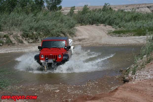
Green mileages boxes indicate the easiest trailsprobably wont need four-wheel drive but should have a high-clearance vehicle. Blue means more difficultstock 4WD required. Black tells you that its the most difficult, which mostly comes in short sections of the traillow range and a lift highly recommended. Red says extremelow gears, low range, traction enhancements, tall tires, and dont come alone. I didnt see any red trails, since I was not only traveling alone but towing a trailer, too, but I did try some black trails. The stock 2007 JK Rubicon Unlimited managed them with some care and scratched underpinnings, but I wouldnt recommend them to most stock SUVs or to solo travelers. The blue tracks proved to be fun, interesting, and non-technical enough so that I could enjoy the scenery.

By following the indicated road (#EM1028) south of the highway you drive through an area called The Squeeze and immediately lose sight of I-70. EM1028 parallels the front face of the Swell as a road, and then turns east while another blue trail continues on along the base of ridge.
. The official title is Three Sisters. I like our title better!")
Approximately 16 miles from I-70, youll hit a paved road (SR24) after about a mile or so of deep, tire-sucking sand wash (N38*46/W110*26). Watch out for this wash and make sure youre either aired down or traveling fast enough to stay on top of the sand. We very nearly didnt make it through this section with highway pressure in the tires and I didnt want to stop and let it down. The scenery along EM1028 is as colorful as youll find in Utahs high desert, plus its a fun four-wheeling trail.

If you continue south on SR24, you can follow the signs to Goblin Valley State Park (N38*35/W110*40) where youll find some really far-out rock formations and an unimproved campground with pit toilets, picnic tables beneath cabañas, and freshwater. This state park is worth the trip.

Back to I-70s Exit 131. This time double back east on EM332, parallel with I-70, for a purely scenic trip. (According to the map, two blue trails head almost due north from very near the off-ramps access road, but I couldnt find them on the ground.) In about 4 miles east of the off-ramp, signage will point you toward The Sinkhole (N38*56/W110*36). The Sinkhole, a natural vertical shaft in the middle of a meadow, is surrounded by a split-log fence to keep the wild horses and burros that populate this area from falling in.
Continue northwest on EM332 and then more northerly past Bottleneck Peak to the junction with EM320 where youll find another unimproved campground. EM332 turns slightly northwest, travels through a very scenic canyon down into Buckhorn Wash where youll find a huge pictograph panel. For maybe 300 feet along the road on a towering vertical cliff face, hundreds of generations of Indians have drawn pictures and left messages for those who follow after. Youll want to spend an hour or two trying to decipher your own messages from those on the wall.

These two trips are just the tip of the iceberg of whats available for you to explore in the swell San Rafael Swell. You could probably spend an entire month here, exploring a trail or two a day, and still never see all that the Swell offers. You may even discover some cliff dwellings if youre lucky!
|
Off-Road.com Newsletter Join our Weekly Newsletter to get the latest off-road news, reviews, events, and alerts! |
Follow @Off-Road
 Your Privacy Choices