
On our last adventure we visited the northern part of Anza-Borrego State Park. After exploring some of the region, we quickly recognized that there are too many trails and things to see in a single day or story. You get hooked and want more!
So we split this off-road adventure into a two-part story: Anza-Borrego North & Anza-Borrego South. Even then, we are just scratching the surface of this amazing region filled with historic and geological wonders. The hope is that giving you, the reader, a taste of Anza-Borrego will get you excited about making your own trek.
If you would like to check out some of the great trails and scenic places in northern Anza-Borrego we visited, make sure to check out the Off-Road.com article here.
DOS CABEZAS & INDIAN HILL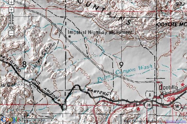
We started our adventure at the south end of the park, near the desert town of Ocotillo, CA and Interstate 8, just a few miles north of the US/Mexico border, and 86 miles east of San Diego, CA.
At the base of the Coyote Mountains, the historical site of the Dos Cabezas train station is a good place to start exploring. The off-roading is moderate, with mostly washboard desert roads and sandy washes. There is one obstacle that requires high clearance if you wish to explore past the station.
With a little imagination, one can be transported back in time when this place was busy with mining activity. A nostalgic feeling of roaring steam engines and mine workers digging the mountains north of the station can be felt. Dos Cabezas, Spanish for Two Heads, is a name given to a nearby water spring that had a stone formation that looked like two heads. The catchy name transcended to a local mine and later this train station.

To get to Dos Cabezas, take the I-8 east of San Diego until you reach the town of Ocotillo, exit Imperial Highway (S-2). Turn left and head north on Highway S-2. Past mile marker 56 on S-2, look for a sign that reads Mortero Wash [N32°47.549' W116°06.433']. Turn south and zero your odometer. At mile 4.1 the old Dos Cabezas train station awaits.
Total distance is around 10 miles with optional side trip to Indian Hills, one of the oldest Native American sites in Anza-Borrego State Park.

For hardcore hikers, the Carrizo Gorge and Goat Canyon is also an option from this point. The highest and largest curved wooden trestles in the United States are here. Whether you're a train buff or just enjoy awesome structural ingenuity, this sight will not disappoint. We plan on making the trek soon and will report our findings.
PALM SPRING & ARROYO TAPIADO MUD CAVES
Palm Spring was a stop along the Butterfield Overland Route that stagecoaches would stop at between the Carrizo and Vallecito stations. Because of its natural water spring and location, a building was erected at this spot in 1858 for a station. The route is important since it made safe overland travel from St. Louis to San Francisco possible.
.")
We did an 11-mile semi-loop with optional side trips to Palm Spring. The trail is easy to moderate, with washboard roads, sandy washes and possible mud during rain season. The area is well marked with signs to the different washes that abound this region.
To get there, look for sign that says Vallecito Wash on Highway S-2, just north from the Carrizo Badlands Overlook. At the trailhead, make a turn onto the dirt road and head east [N32 54.931' W116 14.446'].
Driving east on the Vallecito Wash will bring you to a Y-split where heading north takes you up to the Palm Spring stage stop.

After youre done exploring Palm Spring, head back to Vallecito Wash from Palm Spring and continue southeast to look for the Hollywood & Vine sign. Story has it that this old mail route later became a county road, and signs did exist marking the number of miles until the next settlement. Some jokester decided to paint over the sign.

Continuing southeast on Vallecito Wash brings you to Arroyo Tapiado. Head north at this point to explore one of the largest systems of caves in the United States. At least 20 caves have been identified in this area, with some running over 1,000 feet in length and 80 feet in height.
It's not uncommon to come across weekend warriors exploring or getting their fix of spelunking in these gypsum caves.
 and later a 50-foot dry waterfall (right). Everything up until those points was pitch black. Flashlights are a must for caving.")
The trip back to Highway S-2 from Arroyo Tapiado can be made on Canyon Sin Nombre for a semi-loop.
PINYON MOUNTAIN
One of the most difficult trails in Anza-Borrego State Park is Pinyon Mountain. Talk to any hard-core four-wheeler that has been to the area and youll get a big grin if you mention The Squeeze or Heart Attack Hill.
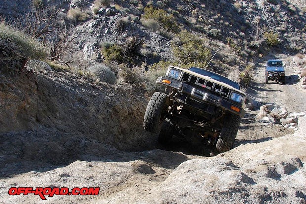
Above: Barney rockin-n-rollin with his 1983 Toyota pick-up on Pinyon Mountain. Believe it or not, Barney started building this truck over 10 years ago. We found an old article in the ORC archives (Photo compliments Beach-N-Toys).
This difficult trail passes through a narrow canyon with steep hills and a hair-raising drop off. This is definitely not for stock vehicles or inexperienced drivers. If you have lockers on your rig, it will make things much better.
The trip is 30 miles one way, starting from Highway S-2. To get to the trailhead, hook up with S-2 either from Highway 78 or north of I-8. Look for mile marker 22 and to the east there will be the trailhead of Pinyon Mountain Road [N33°03.246' W116° 24.464']. The one-way run takes you down into Fish Creek, where you can head north on Split Mountain Road, back into Ocotillo Wells and Hwy 78.
.")
Pinyon Drop Off (a.k.a. Heart Attack Hill) isnt just a cute name its for real. In several of the guidebooks we referenced for the trail, warnings about this section are boldly stated. This is not for beginners or 4x4s with poor off-road capabilities.
")
A combination of experience, equipment and good a spotter will make the decent easy-breeze. Anything less could end you in the hospital. Dont believe us? Take a look at this video that has been floating around cyberspace. If that doesnt give you a heart attack, I dont know what will.
Video: Heart Attack Hill Roll (Not for queasy stomachs)
MAKE PLANS & PACK YOUR BAGS
Well, there you have it: Anza-Borrego - South. History, adventure and plenty of thrills are all in one place. We hope you will make it out to Anza-Borrego soon, preferably in the cooler months (anything under 100 degrees). The park is open year round, so any time is a good time.

Camping spots are abundant throughout the park. If youre looking for RV parks, hotels and such, Borrego Springs is your best bet. Check out the Borrego Springs Chamber website for more info http://www.borregospringschamber.com/
See you on the trail.
RESOURCES
We highly recommend the following guidebooks for planning and referencing trails and important landmarks in Anza-Borrego:
The Anza-Borrego Desert Region, by Lowell & Diana Lindsay http://www.wildernesspress.com/product.php?productid=16734
California Desert Byways, by Tony Huegel
http://www.backcountrybyways.com/calidesert.shtml
Trails.com (eGuidebooks & Topo Maps)
http://www.trails.com/
SOURCES
Anza-Borrego State Park
http://www.parks.ca.gov/?page_id=638
|
Off-Road.com Newsletter Join our Weekly Newsletter to get the latest off-road news, reviews, events, and alerts! |
Follow @Off-Road
 Your Privacy Choices