Access to Get In, Places the Trails Take You, Things Youll See
In our years writing about backyard off-roading (neighborhood trails you can hit without blowing a whole day), this one might have been the closest to our Fletcher Hills headquarters. Less than 20 minutes out of the driveway, we were poking around the exit at Willow Road in Alpine, CA, for the turnoff to the Victoria Drive loop. Backtracking west on Alpine Boulevard led us to Victoria at a freeway underpass, and up the hill to Anderson Road, which becomes Anderson Truck Trail. Our backyard adventure is related to our San Diego locale, but the idea of backyard off-roading is that many of us have trails close to home that may or may not be the most challenging, but they offer a quick off-road escape that doesnt require an entire weekend to accomplish.

Anderson Truck Trail: San Diego County
Pros:
- a fun, as-sporty-as-you-like trail that terminates above El Capitan Reservoir (way above it)
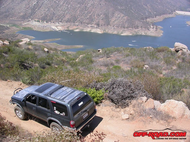
- a killer views of lake and surrounding mountains like The Captain
- challenging terrain is available on several spur trails that splinter off the main
- lots of room to play, practice or test equipment on aforementioned spurs
- useful interconnects between sections of trail
- popular but not crowded
- you can get home in time for lunch
Cons:
- the trail isnt long less than five miles of it is truckable (realistically), and you leave the way you came
- even the difficult sections of trail arent that challenging the offshoots never get above a three on the five-scale
- Super-Duty-sized trucks will have a tricky time in a few of the turns, so leave your longbed at home if you dont want bush-rash
- some of the trail users can be... jerkular... whether or not youre nice
- get over the fact that people built homes up here

The trail begins at an altitude of about 2200 feet. It helps to zero your odometer. You will climb, but plan to drop as much, and then more Anderson Truck Trail works its way overland to the edge of the ridge overlooking El Capitan Reservoir, and anyone with a good wheel can then drop over the edge a ways and really enjoy a view of El Cap with their picnic brunch.
, the network of auxiliary trails branching off Anderson Truck Trail makes for a decent selection of terrain features. Some of those features are strictly biker-style, but most are truckular.")
Youll quickly realize that youre driving a backyard trail several driveways to homes (including properties burned out in past fires) click off to the left and the right, and in some cases, youll be making a spectator sport of their back yards. Youll encounter gates or warning signs in most cases, but prepare to back out if you arent paying attention. At one sign 599 bear right, and youll see batch of homes to your left shortly thereafter. Another set of homes lies off to the right past two miles in. There will also be a number of wide spots where folks park to climb nearby Viejas Mountain, or to unload their motorcycles and bikes. Remember to wave you never know when one of them will be able to pull you out.

Youre done passing homes when the trail gets lumpy. At this point, its no longer a driveway, but honest backcountry access. Several offshoots pop up, including a high-quality spur to the left about three miles in. The main road bears right there, though at several later intersections it heads left. You can usually identify spur trails because they quickly get weirder than the main road. Dont be afraid to experiment, but remember where you are. The complex of spurs to the south of Anderson Truck Trail work their way toward a generally flat mesa to the south, where numerous interconnects loop back and forth into each other, and can be driven back to the main trail if you manage your sense of direction. Its in areas like this where that awareness where youre headed, where the main trail is, where you want to wind up is essential. Pay attention (not only to yourself but to others on the trail) or you might just fall in the lake. Literally.

Hard Points: What, Where and How
Route and Trailhead: Anderson Truck Trail (15S30), accessible from Victoria Drive in Alpine, ala the 8 freeway.
Terrain: graded dirt/rough dirt/heavily rutted dirt/washed-out dirt road, some narrow sections, expect to pucker once or twice, longer rigs might need to multipoint a few turns or back up, spur trails vary greatly and can get interesting.
, its likely well see these dudes again. Hi!")
Necessities: main trail = two-wheel drive with good articulation/four-wheel drive for trucks that dont flex, good tires, a brain; spur trails = four-wheel drive, advanced vehicle control, a rear locker would be helpful.
Your Skill Level: main trail = novice with instructor/spotter or better; spur trails = intermediate, or novice with instructor/spotter and another truck, or better.
Authors Equipment: third-gen 4Runner with more mileage than Apollo 11, four-wheel drive, rear locker, custom three-inch lift, worn Goodyear Wrangler Silent Armors @ 25psi, plus skills.

Local Trail Means Popular Trail Mind Your Step
There will be others with you in the bush this is a popular set of trails, close to San Diego proper. Some folks come out to shoot, though it is our impression that it is not a legal area to do so; theres plenty of BLaM land nearby where its perfectly okay, so dont push it. Other users of Anderson Truck Trail include mountain bikers lots of them and the two-wheel enduro/dirt bike set. Most of these folks, including all we met on this run, were plenty friendly once we warmed them up. Several hikers were also encountered, and their friendliness was less consistent. All of these folks should haul out what they bring in, though youre bound to find some litter they left behind. Remember, the granola crunching foot-only elitists are not just interested in getting trucks off these trails, they want bikes gone too (witness several cases of bikers being banned in Orange County and San Diego, for example), so People of the Tire need to stick together. We should all support trail-sharing organizations like Blue Ribbon Coalition.

The Drop-In to El Caps Viewpoint Watson
A friend of the author, who goes by Black Ryan on a local gearhead radio show called the Garage Hour, rides Anderson Truck Trail frequently. He described the point about five miles in where the trail necks down to barely truck width (at a landslide that took some trail with it). He said this is where to stop going forward: shortly past a stand of old scrub oaks, theres a wide point in the trail followed by Black Ryans Gap, which all but advanced trail rigs would be unable to pass. It was our impression that a third-gen 4Runner could have squeezed through (right?), but without a spotter and only limited recovery gear, we werent going to try. Black Ryan said the trail continues on its tight and windy way beyond the pinch, but dont assume you can make it without serious effort. Plan to return the way you came. If we didnt believe him, he suggested we find and ask the owners of at least four trucks balled up below the trail. Not everyone on-trail is nice, including whomever tumbled these stuck trucks down the mountainside instead of helping retrieve them.
About four miles in, youll come across a wide section of trail, with a large circular turnaround and two spur trails heading north and south. Try them both, and learn a little about this network of trails for yourself. If youre out here in your big-boy truck, this is the place to turn around the trail tightens on the downhill. Anything longer or wider than a half-ton with the standard bed will probably pick up a scratch or two, and unlifted two-by trucks might not have the clearance for a few of the ruts.

Past the barricade just west of the wide big-boy turnout, Anderson Truck Trail meanders downhill over a rutted, partially washed-out dirt road. Youll be in first or second gear, and probably on the brakes. When the trail begins to straighten and you can see the lake (preferably on your right), youre almost out of road. Past a copse of old scrub oaks, the trail widens just enough to pull to the side of it, and then necks down at Black Ryans aforementioned pinch; wed recommend you avoid it. Heres where you either K-turn the trail to head out, or prepare to back fifty feet to pull a K under the oaks. For most, this is the end of the trail, though mountain bikers, motorcyclers and hikers would take this section of trail downhill to Peutz Valley Road. You could (!) go further, though not with our recommendation. If nothing else, walk a few hundred yards of the narrowed Anderson (Not Very) Truck Trail and see for yourself. Then spend a few minutes admiring the vehicles that did not survive the maneuver you are considering.

It should be noted that we never used four-wheel drive or the rear locker on the main trail heading in or out though they were handy on the offshoots. However, if your truck does not boast the extensive articulation of a modded 4Runner (particularly the rear axle, which would wander off if it didnt have a leash), four-wheel drive will probably be necessary.

Trails like this speak to the usefulness of narrower tires. While this selection is less effective in the sand of San Diegos desert terrain (witness this 4Runners inability to climb San Dam after a dozen tries, while matching 4Runners with wider tires can), it is ideal for tight trails and lumpy rock crawling the author prefers better steering, narrower footprint, more accurate tire placement. Of course, in this case, we used a tired set of the Kevlar-booted Wranglers that just refuse to curl up and die, and they were more than enough.
|
Off-Road.com Newsletter Join our Weekly Newsletter to get the latest off-road news, reviews, events, and alerts! |
Follow @Off-Road
 Your Privacy Choices