Video: Bradshaw Trail - Overland Route to the La Paz Mining District

Gold and new opportunity out west were a common theme of the 1800s. Placer findings made dreamers believers, and stories of great deposits in remote areas made men go to extreme measures to strike their claim. On our latest off-road adventure, we traveled along the Bradshaw Trail, historically known for being an overland route used between 1862-1877 to transport miners and goods to the La Paz mining district in Arizona.
The Bradshaw Trail has been on our off-road adventure list for quite some time now. When the opportunity came up to join Tom Severin and Dave Druck for an early January trip, we were very excited to finally make this happen, especially with a good group. So we started making plans, prepped the vehicles and packed for our weekend off-road adventure. Both Off-Road.com editor Josh Burns and myself were able to make this trip, our first off-road adventure for 2013.
 and Dave Druck (right) give our group a rundown of the route we would be driving and some of the things wed see and do along the way. HAM, CB and FRS Radio equipment test also took place.")
The group met just north of the Salton Sea at the town of Mecca, CA. Our convoy was made up of several Jeeps, Toyotas and even some domestic iron. Dave Druck was our trail leader, having made numerous Bradshaw Trail excursions in the past. Tom Severin brought up the rear. We had over 20 people on this trip, making it a very good turnout for this 2013 off-road kick-off trip.
Get the Flash Player to see this player. |
HEAD EAST YOUNG MAN
When placers in the La Paz district were discovered by Captain Pauline Weaver in January 1862, miners that had exhausted their diggings in California were eager to jump onto the next big mining bonanza near the Colorado River. The routes heading east to La Paz were limited, with the Mojave Road and the Butterfield Overland Route as the only overland options. The problem with these routes was the fact that they put travelers really far north or south of La Paz.

William D. Bradshaw, a miner and western guide, recognized the need for a better and more direct route to the mines along the Colorado, so he assembled an expedition party of nine and set out to find this route in 1862 using some existing stage roads and trails.

While exploring, Bradshaw was befriended by Old Cabezon, chief of the Cahuilla Indians of the Salton Sink and a Cocomaricopa Indian mail runner from Arizona. The two Indians shared with Bradshaw a map of an ancient Halchidoma Indian trade route through the Colorado and Sonoran Desert. The route map included exact locations of springs and water holes, which are important to survival in the desert.

Bradshaw and his men ventured off to explore this unknown desert territory between the Orocopia and Chuckwalla mountains on the north and the Chocolate Mountains to the South. They travelled east, following the map drawn by the two friendly Indians until reaching the Colorado River near present day Blythe. After crossing the Colorado, La Paz was less than four miles. Bradshaw had found a shorter route to the La Paz Mining District.
Soon, an overland stagecoach service was set up using Bradshaws route, as was a ferry service across the Colorado River.

The La Paz District and other mines along the Colorado River eventually declined, followed by the expansion of railroads into Southern California and Arizona. By late 1880, passenger traffic, freight and mail had disappeared from the Bradshaw Trail.
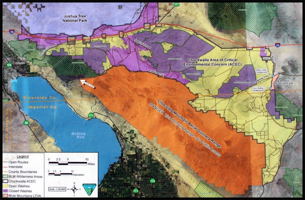
Much of the original Bradshaw Trail is still accessible by motor vehicles today. Starting about 12 miles east of the community of North Shore near the Salton Sea. The route spans 70 miles east to west to the banks of the Colorado River, just south of Blythe, California. The Bradshaw Trail provides rich history of early trailblazers, military activity and pioneers--along with scenic desert and mountain vistas. The terrain varies from graded dirt road to sandy washes and sometimes even challenging terrain that requires good four-wheeling skills. Along the Bradshaw Trail there are numerous interesting stops and side trips that give this adventure its distinct flavor.

Come along on this historic journey as we re-discover this great overland route to the gold fields of La Paz. Hopefully it will inspire you to make your very own Bradshaw Trail adventure.
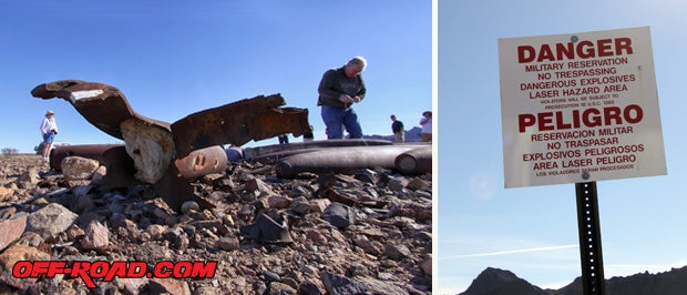
The Chocolate Mountains Aerial Gunnery Range borders a part of the Bradshaw Trail to the south. This is a live bombing range and posted as closed to public entry. Some DUD bombs rest along the side of the trail and can be approached for closer inspection. Just make sure to stay behind the DANGER line.
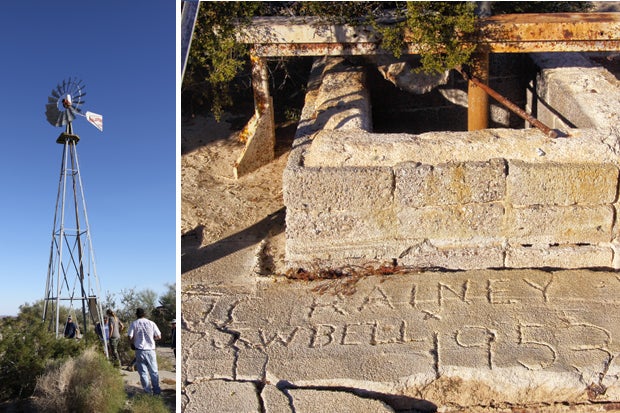
Dave took us on a little side trip to the old Bell Ranch. A water-pumping windmill still stands on site, along with some interesting animal watering holes. We didn't find any corrals or cattle, only some cement with the name J.C. Rainey and J.W. Bell, dated 1953. Information on this place is limited, so if you know anything about it, please let us know.
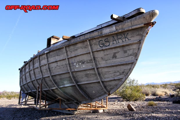
We love desert oddities and the GS Ark along the Bradshaw was a great find. Coming across this large vessel in the middle of the Colorado Desert is very odd, to say the least. Its textured ribs and weathered skin give it great character, reminiscent of an old ghost ship or tattered caravel. The GS Ark first appeared sometime in early 2010 and it appears to be boat-making mold, and theres no official word on where it came from or how it got to its resting place. All we can say is dont miss the boat.
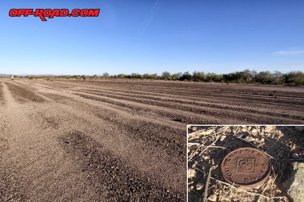
On our last stop for day 1, Dave showed us an old U.S. Army training site filled with WW II tank tracks made during exercises in the 1940s. Under the command of Major General George S. Patton, the California-Arizona Maneuver Area (a.k.a. Desert Training Center) was created in 1942. Camp Young, located just a few miles north from here, was the headquarters. While walking the tracks, we found an old Copenhagen Snuff container just on the other side of a bush. A little research after the trip revealed that it is of 1940s vintage. A soldiers perhaps? Or maybe a cowboy.
|
Off-Road.com Newsletter Join our Weekly Newsletter to get the latest off-road news, reviews, events, and alerts! |
Follow @Off-Road
 Your Privacy Choices