In the first half of our off-road adventure through Death Valley National Park we followed tracks made by early 49rs seeking gold out west. We overcame extreme weather and roamed the mystical desert scape of the region. We even passed through the hippy cult hideout of the Manson family, among other desert oddities.
Off-Road Travel: Death Valley Part 1
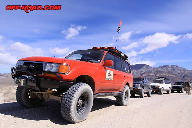
Continuing our exploration of this vast 3.4-million acre National Park, Tom Severin from Badlands Off Road Adventures led our group toward the western boundaries of Death Valley and the geological phenomena known as the Racetrack.
Our convoy left Mesquite Springs early in the morning. We made a stop along the way at Ubehebe Crater--a large volcanic crater that is half a mile wide and over 500 feet deep. Its estimated that the crater is 2,000 to 7,000 years old. Big basket in the rock is the translation of the Timbasha Native word Ubehebe.

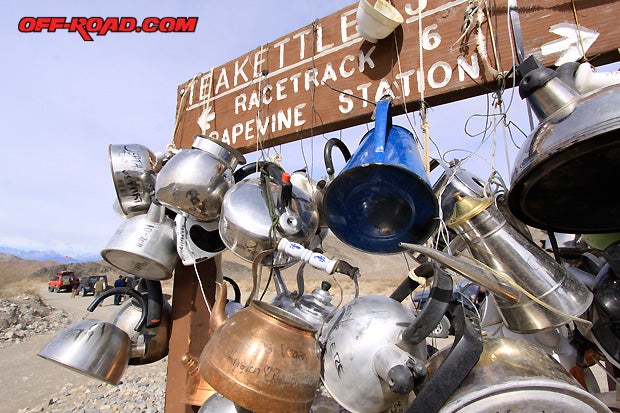
From this point, a washboard dirt road lined with occasional sharp rocks spans about 20 miles until reaching Teakettle Junction. Once at Teakettle Junction, we had to stop and check out the collection of teakettles hanging from a wood sign at the intersection. Its interesting to see the different styles, sizes and origins of teakettles and their owners. We read signatures from visitors as far as England, France and Germany. These desert oddities make the trip fun.
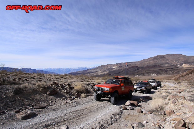
Done with our tea break, we continued toward the Racetrack. The area got its name from rocks that skate across the playa and leave tracks behind. Less than a mile away from Teakettle Junction, a large flat area known as the Playa greeted our eyes. In the middle of the flats, a rock outcrop stands known as the Grandstand. From this vantage point a number of rocks can be seen across the flats. The interesting thing is that this race has been going on for millions of years.

There are two good stopping spots along the Racetrack to get a view of the rock action, one across from the Grandstand and the other at the south end of the playa. You cant drive your truck on the flats, but you can get out walk onto the playa to get a closer look.
THE LIPPINCOTT 4X4 TRAIL
Most people get as far as the Racetrack and then turn around. The Lippincott Pass is one of the more challenging trails in Death Valley. Its not even on the official park map--that tells you something. Tom seemed confident going down it, so we followed our fearless leader.


The Lippincott Mine was in operation from 1906 to as late as the 1950s. According to George Lippincott, Jr., the Lippincott Mine produced and shipped ore during World War I. During the World War II, the Ubehebe Mining District was utilized as a practice field for aerial gunnery exercises by the U.S. Government. Mining was shut down during this period. By 1946 Lippincott's Southern Lead Company had resumed operations and with a nine-man crew was producing two carloads of lead weekly, which were shipped to Goldfield, Nevada (Source: NPS).
Driving down the Lippincott trail had some pucker factor, but going up it would be just as challenging. We came across a group of adventure motorcycle riders who were attempting to get to the Racetrack from the Saline Valley below. The last stretch of the Lippincott trail literally bucked them off the bike. A high-dollar BMW GS1200 motorcycle toppled over on its side and the rider had to be assisted by a fellow rider. Its very steep terrain.

Down at the foot of the Saline Valley, Tom steered us to the north. We had a good time breaking loose from 4-lo to some high-speed desert travel along the Saline Valley Road, which runs along the Inyo Mountains. Running the entire Saline Valley Road is a trip in itself. It runs just shy of 100 dirt miles. We only did a section leading to Saline Springs.
Our day quickly came to an end, but before we rolled into camp, we made a stop at a primitive ore mill Tom knew about near the Saline Springs.

We camped at Saline Warm Springs for the night. The place is an oasis in the Saline Valley. It has natural hot springs and campsites taken care of by Lizard Lee. Death Valley National Park does not promote the area, although it is within the park boundaries. Part of the reason for this may have to do with the dress code. The area is clothing optional, so dont be alarmed if you spot birthday suits.
The Saline Warm Springs are not easily accessible, so anyone that is soaking in these tubs worked hard to get here. Theres an interesting article in the New York Times if you want to learn more about them.

The next morning, we suited up and moved past the Saline Warm Springs. Heading northeast, Tom took us toward Metal Pass. The trail climbs above the Saline Valley and is only recommended for high-clearance 4x4 vehicles with experienced drivers. The tight rock section at Metal Pass can be a challenge without a spotter or proper equipment.
Along the way, Tom stopped to show us another tub, but this one was different. It was yet another desert oddity. Someone filled a white cast iron bathtub with blue marbles to simulate water. There were even some bath toys floating on top, just for the fun of it. Rubber Ducky, Youre the One...


Crawling past the rocks, we dropped down to the Eureka Dunes located in the remote Eureka Valley. The enclosed basin located northwest of Death Valley (Elev. 3000 ft.). The dunes cover an area only three miles long and one mile wide, yet they are the tallest sand dunes in California--and possibly the tallest in all of North America.

The Eureka dunes rise more than 680 feet above the dry lakebed at their western base. Vehicles can't drive on these dunes, but you can hike them. It's said that when hiking the dunes one can hear them sing. When sand avalanches down the steepest face of the sand dune, a sound like a bass note of a pipe organ can be heard coming from the sand.
After stopping at the Eureka dunes, our off-road adventure came to an end. We aired back up before getting back on pavement, and then we headed into the little town of Big Pine to top off on fuel before heading back to the concrete jungle.
We only spent a few days in Death Valley, but we already are making plans to return and explore some more. Theres so much to see and do--weve only touched the tip of the mountain. Hope this Death Valley off-road adventure gets you excited about visiting the national park.
Some great reference and guidebooks exist to help plan your trip. We recommend:
California Trails - Desert Region
By Peter Massey, Jeanne Wilson, Angela Titus
http://www.adlerpublishing.com/
California Desert Byways Wilderness Press, Tony Huegel https://www.wildernesspress.com/
California Backroads & 4-Wheel Drive Trails Funtreks, Charles A. Wells http://www.funtreks.com/
Trails.com Death Valley 4x4 Trails (Online trail guides)
http://www.trails.com/
You can also book a trip with our friend Tom Severin, and let him take care of all the details. Just show up with your 4x4 and a sense of adventure, hell take care of the rest.
Happy Trails!
SOURCES
Death Valley National Park - CA, NV
http://www.nps.gov/deva/index.htm
Badlands Off Road Adventures
http://www.4x4training.com/

|
Off-Road.com Newsletter Join our Weekly Newsletter to get the latest off-road news, reviews, events, and alerts! |
Follow @Off-Road
 Your Privacy Choices