Weve been insisting that you get your truck in the dirt. The worlds driveways and parking garages are full of able rigs that could take you to whereabouts unknown: Troopers and Samurai, Tacomas and Explorers, half-ton this and four-wheel drive that, Wranglers with no dirt under their nails and Land Cruisers that only cruise the drive-through.
Off-Road.coms Backyard Off-Roading series aint about planning distant adventures to remote places (though were all about the adventurism you do that), but local trails. If you know a brunch run a half-hour from home, run it before brunch. If theres a great trail just out of town that lets you watch the sunset, chase it to the horizon. However, if you find youve found all the neighborhood trails, and you have a day to spare instead of a morning, its time to reach a little further afield and make your backyard a little bigger.

A few hours north of San Diego is the Los Angeles-adjacent mountain community of Big Bear. In addition to its skiing and snowboarding, it provides SoCal-based off-roaders a high-quality mix of terrain. If you like desert-like rock, cactus, and scrub pine-infested two-track, interesting/difficult/entertaining rock gardens, or tight switchbacky high-altitude trails knotted through mountain pines, Big Bear has it. A few weeks back, a friend wrangled up a plan for few off-roading buddies, and we connected on a Friday evening at Cactus Flats, a generous staging area northeast of Big Bear City. The next morning, we hit Jacoby Canyon Trail.

Jacoby Canyon Trail, San Bernardino National Forest (Big Bear)
Pros:
- Provides trail-hounds just enough sporty spots to make the run worthwhile.
- Challenging enough to get your blood up, but not so ridiculous that your kids will puke.
- Serves as an excellent intermediate trail for newbie off-roaders to expand their skills.
- Timely connection to the ridge route (Holcomb Valley Trail 3N16) makes Jacoby Canyon an ideal morning run.
- Connects with the other Holcomb Valley-based trails in short order from an eastern access point that sees less traffic than more popular trails that spring up from around Big Bear, Baldwin, Arrowhead and Silverwood Lakes.
- Enough mining and other mountain-like history was created in this area that you can poke around in the bushes with an actual chance of finding interesting junk.
Cons:
- Some of the trails in this area are closed for the winter. Minor bummer, but bummer nonetheless.
- We couldnt help but notice that the rangers in this area were not terribly friendly. Perhaps someone had mucked up the coffee that morning, or perhaps they dont like the four-wheel crowd. Either way, try to be nice.
- As Jacoby ends high in the hills, youll need to plan ahead for your exit.
- This is California, so you need to buy an adventure pass if you plan to park for any extended period of time (yes, Calif. even taxes you to have an adventure).
- Not an ideal trail for anything bigger than a half-ton short-bed, and it would be more overgrown in the summer, so mind the bush rash.


Hard Points: What, Where and How
Trailheads: Jacoby Canyon Trail (3N61) has only one paved-access entrance, that off of State Route 18 just north of Cactus Flats (which is accessible via 3N03). The Jacoby turnoff is obvious (see picture) but its not well marked. If you dont see a giant overhanging rock within a mile of beginning the trail (also pictured), its not Jacoby Canyon. Jacobys backdoor is nearer the top of 8235-foot Gold Mountain (above 7000 ft., actually), where the trail abuts 3N16 (the lengthy Holcomb Valley Trail), which is the ridge route that interconnects more than two dozen other high-mountain trails in the area north of Big Bear Lake. Egress is easy there are at least five southbound trails that will take you back to town, including a Sunday drive down the eastern spur of 3N16. Bring a map, as there are enough shunts up there to get the wrong sort of lost.

Terrain: main trail = not very graded dirt two-track combined with rock jumbles and several canyon-bottom creek beds doubling as playgrounds. Lots of loose rock more than is typical for California trails. The trails never too narrow, so dont worry about getting pinched. Youll need to have your brain with you, but the hardest points of this trail are in the first mile. There were offshoots, but we didnt explore any. Dont venture off the beaten path without backup or a plan.

Vehicle Requirements: main and spur trails = respectable ground clearance and appropriate rock and trail-friendly rubber are necessary. This is not a trail for your wifes Subaru. However, there are no grievous high-angle or pinchy trail points on this run, so though we usually recommend real four-wheel drive and not all-wheel drive, an all-wheel driven vehicle (think MDX or Cayenne) with the right tires could probably handle Jacoby just fine.
As for the right tires, our benchmark minimum for this trail would be something with lug and construction akin to a Goodyear Wrangler Silent Armor. Weve used them to great effect on a third-gen 4Runner as a multi-purpose trail and street tire.

Skill Requirements: main and spur trail = established trail awareness and truck-control capabilities; advanced beginner to intermediate. This aint a trail for a first-timer. Maybe a second-timer. No high-pucker spots to get your fear up, but some of the rockier moments require tire-placement radar, a smart foot and a little bit of the Force.

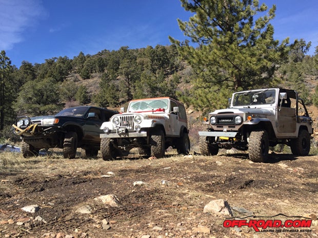
Author and Friends Equipment: third-gen 4Runner with more rings than the Methuselah Tree, four-wheel drive, rear locker, custom three-inch spring lift, Goodyear MT/R Kevlars at 20 psi; as well as a small-blocked and locked five-speed CJ-7 on 33-inch Goodyear Duratracs with a four-inch BDS spring lift, and a small-blocked but not as locked six-speed FJ-40 on 33-inch Adventuro M/Ts with three extra inches in the springs.
Some Snow Didnt Mean No: Jacoby was Just Right
As of Saturday a.m., the crew had only one must-do revisit Gold Mountain Trail, which would satisfy someones urge to complete it, and a day to do it. Everything else was, as they say, gravy. Using with maps provided by local off-roading groups like the SoCal Mountains Foundation (sponsored by Yamaha) and Backcountry 4x4, Jacoby Canyon Trail (3N61) quickly identified itself as the best connector from lowlands to the ridgelines. Jacobys eastern-facing entry point was close to Cactus Flats, and it would deliver us to the trail complex north of the lake itself in about three miles. While you may enjoy GPS and/or sat-mapped trail information, its hard to tell if a dirt track is a road or a boulder field from space. Local-based knowledge and reliable printed maps are always, in our opinion, necessary (and get better reception).
 were these tree channels that came with increasing altitude.")
Jacobys lower entrance begins south of the Cushenbury Grade on State Route 18, just north of the Cactus Flats staging area. We had no idea about its current condition (thats part of the fun), though it was marked in blue in one of the maps, which we figured employed a green-easy/blue-intermediate/black-difficult marker, as with area ski hills. So long as winter conditions hadnt made the trail impassable, we planned to give it a go, as it was clearly the shortest route from where we were to where we wanted to be. Keep in mind, when off-season off-roading, heavy weather can mess up a trail in short order, so dont be surprised by washouts and rockfalls, and in the case of high-mountain play in the winter, more snow than you can shovel.
 snow and altitude. Got to love the retro paintjob.")
By making our run in the guts of winter mid-February, to be exact the trails available to us were not 100% of what the Big Bear area has to offer. Some were closed to keep folks from going waist-deep into the mud, others had too much snow on them. Jacoby begins at SR18 at about 6000 ft. above sea level, however, so its not in as vulnerable to significant late-season snow as the higher reaches of the San Gabriel Mountains. In fact, it was warm and relatively dry as we dropped off the pavement and headed uphill.
The trail quickly deteriorates into its ugliest conditions. Off-roaders will encounter several lumpy sections of trail composed of uneven, loose rocks within a mile of Jacobys beginning. Have faith: this is the toughest of the trail. Patient tire placement with judicious throttle and brake control will deliver you to a more open high glade/semi-scrub forest in less than 20 minutes. When you begin dropping again, the trail connects with and roughly follows Jacoby Canyon and the seasonal creek that runs through it.
 historical mining remnants. They stated that the easily found goodies had been found (easily, we presume), so they didnt expect to find much (thus the adventure, eh?). This area had once had serious gold deposits, so who knows?")
At the point you hit the creek bottom, youve driven about 9/10ths of a mile, and passed up, down and up a subtle series of ridges that make up the first third of the uphill trail. The terrain begins to look much more mountainy, with tall pine and more mud and rock-based surfaces replacing sand and rock. There will also be, at least in February, significant snow drifts and the associated mud on-trail. There are offshoot trails to entertain, so Jacoby could be a full-day playground if you like, but as mentioned, we were headed for the top, so we didnt.
Jacoby Canyon Creek is a Fun Place to Play
The narrowest section of this trail climbs in a drunken parallel with the creek bed up Jacoby Canyon. The narrow two-track dips into and out of the bouldery creek bed regularly, but this is the narrowest section of trail that youll encounter on Jacoby. If you step wisely, the trail never becomes difficult. As stated earlier, you could also step in a more adventurous fashion and turn these rock fields into high-Q entertainment, as can be witnessed by some trail-friendly folks videos weve seen on You Boob.

While slow going due to regular re-entry and exits from the rocky drainage of the creek, the second mile of Jacoby might also be the most satisfying. Less direct than the first third, the second mile is graced by substantial forest and other established growth, repeated engagement of challenging trail surfaces that can either be engaged or bypassed, and several clearings that invite visitors to poke around in the wreckage of history heaped around the trail foundations, old machinery, wrist-thick steel cable and other offerings by mankind past to the slow creep of Mother Nature.
The final third of Jacoby is easy to delineate, as the trees begin to thin and, as a February run would predicate, theres a lot more snow to push through. Snow driving is a hoot, with traction on and off and on again depending on which tires in a puddle and which is on a rock, while another is in the air and a fourth is hub-deep in snow. Youll use your lockers more in snow than on the regular trail surface. The top of Jacoby ends at a T-intersection with 3N16. Keep right to head deeper into the trail complex and the remnants of Doble Mines main portal, or hang a left to drop down to Baldwin Lake.

At a few spots near the top of the trail, youll pass through private land, but it isnt an impediment. Rundown fences or barbed wire usually indicate passage into and out of private land; until this point, the entirety of Jacoby Canyon Trail is in the San Bernardino National Forest. Most of the privately held land up at the top is or was a mining claim, as this area was extensively harvested for minerals in the late 19th and early 20th centuries. Lots of interesting holes and former mining ingress and egress are to be found up here, though, according to the locals, not much is left of the extensive leavings of history that once littered the area as a part of the expansive Doble and Gold Mountain mine workings. Alas, many of the better mountain portals have been blown or avalanched shut, so youll need to enlist the direction of local rock-hounds and geologists to get a idea of where to search for that sort of thing.
References:
Backcountry Adventures, Southern California; Peter Massey and Jeanne Wilson, Swagman Publishing 2006
Big Bear Backcountry Adventures; Don Alexander and Cindy Morley, Backcountry 4x4 LLC 2014
California Road & Recreation Atlas; Benchmark Maps, Benchmark Maps 2007
Off-Highway Vehicle (OHV) Guide; Southern California Mountains Foundation and Yamaha Motor Corporation, 2014
|
Off-Road.com Newsletter Join our Weekly Newsletter to get the latest off-road news, reviews, events, and alerts! |
Follow @Off-Road
 Your Privacy Choices