Do stuff! Palomar Divide is a picnic run not because its easy (though most of it was dont stress this one), but because it was long enough that youll want to bring some leftover pork chops and a bottle or two of sauce for lunch. That said, the daylight required for this trail adds interest: Palomar Divide Road is an approachable, safe and occasionally sporty run through San Diegos mountainous backside thats a great drag-the-kids-along off-road trail that can fill a casual Sunday or half a Saturday.

Palomar Divide Road and Truck Trail: San Diego County...
Pros:
- A good driver youll climb and climb, and when you do youre really there.
- Rare views of the Palomar range, from its rarely visited eastern side.
- Additional remarkable views of the Palomar Observatorys telescopes.
- Access to one of Californias few remaining (much to fire professionals chagrin) operational observation towers, High Point Lookout.
- Enough local color before and after the trail (as well as en route) to make touristy excuses for the run as if you needed them.
- Several historic buildings and mine sites are ripe for exploring get a good local map like the Forest Service map of the Cleveland National Forest.
Cons:
- Blocked continuations and connecting trails this solitary trail could be a high-Q complex if so much of it wasnt closed off by taxpayer-glutted bureaucracy. We counted four locked gates, and theres probably a few we overlooked.
- Its a day run masquerading as a morning run.
- The terrain isnt tough unless you make it.

. We had a good chat with the ranger; these guys are out here solo so they appreciate your appreciation, and are loaded for bear. Literally.")
Hard Points: What, Where and How
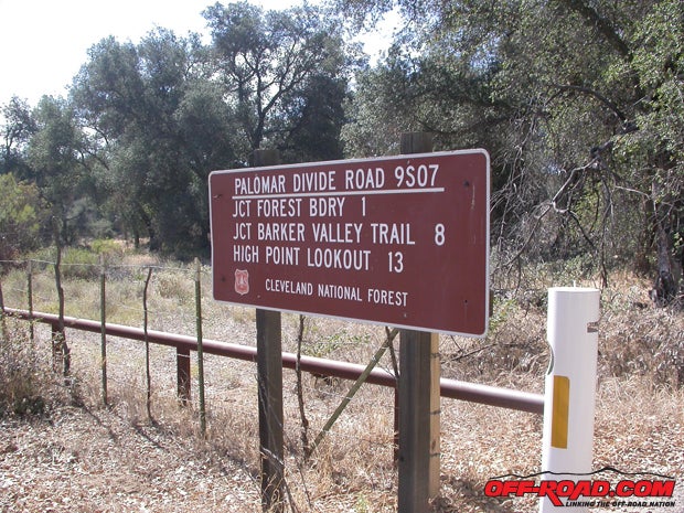
Trailheads: the Palomar Divide run (Palomar Divide Road 9S07, briefly 9S09 and then High Point Road 8S05) has northern and southern jump-off points. Access from greater San Diego is cake 8 east to State Route 79 north, or State 67 through Ramona to the selfsame 79 north, both taken past Warner Springs. Look for the partially concealed dirt turnoff to 9S07 on your left about three miles past the glider port. To approach the trail from the north, grab the 79 east out of Temecula (hard aside the 15 freeway), and about 12 miles along youll find the trailhead cleverly concealed as a slightly upscale mobile-home park near Aguanga. At this end, the trail is known as High Point Road (8S05), which connects with 9S09 to the 9S07 near the observation tower.

Terrain: main trail = graded dirt/rough dirt; spur trails = occasionally rutted, rocky loose dirt, some sloppy two-track. The Palomar Divide run doesnt have much to sweat for a competent off-roader. Thats a good thing if youre out with the wifey and kidlings for a lunch run or breaking in a newb.
Vehicle Requirements: main trail = a little bit of clearance and good tires will make two-wheel drive enough (Subarus and other all-wheel drive guys will do fine as well); spur trails = four-by helps, plus tires that you know. There are very few tight turns, but none would disqualify a longish truck.
Skill Requirements: main trail = newbie; spur trails = practiced newbie or better vehicle control. The biggest caveat would be to be prepared for a longer day on the trail.

Author and Photographers Equipment: third-gen 4Runner with more rounds in the ring than George Foreman, four-wheel drive, rear locker, custom three-inch spring lift, worn Goodyear Wrangler Silent Armors @ 22psi; accompanied by three-inched FJ80 on Wrangler MT/R-Kevlars, four-by and locked all around.

Heading for the Fire Tower from Palomar Divides Southernmost Point
The run up and down this old fire road is about 20 miles from head to foot, and it will take you a good length of the Aguanga Mountain/Palomar Mountain ridge complex. We racked up more than 25 miles running roughly northwest, but that included poking around on every spur that looked like it needed some Toyota. Youll see more folks and vehicles on-trail during the hunting seasons, and with at least one mine in operation on Aguanga Mountian (the formerly cool touristy viewpoint known as the Ware Mine), there is some equipment use. When you spot the gated Ware Mine (about where the semi-paved road surface ends), youll note noteworthy tailings piles on the opposite side of 9S07, remnants of the Maple Lode and adjacent mines.

Most of this Forest department road runs in the patchwork Cleveland National Forest, so youll encounter campers, hikers and bikers as well, and the drop-in trail known as Barker Spur heads west from the Divide Road a scosche north of Palomar Divides intersection with the unfathomably gated (dude, why?) Halfway Road (9S06).
 in short order. Though the claim is fenced (minerals are soooo 2015), theres a lot around it thats not.")

As the trail never gets too hairy, we didnt overdo dropping tire pressure, and 22 psi will work on a good tire all day long, and so long as youre not moving at freeway speed it wont generate too much sidewall heat. 9S07 is mostly washboard and lumpy gravel-type stuff following the poorly paved section approaching the Ware Mine.


 out of Holcomb Village on the 79 had a Jeep on the other side, so it obviously wasnt locked to prevent access, just to prevent getting somewhere. Someone with good aim had a bigger problem with it than us.")
Northwest past the Halfway Road intersection, youll encounter a few slightly puckery spots of limited trail width, but again, if youre careful, its not a big deal. Its such a not-big-deal that you could easily run a Super Duty Ford the full length of this run.
.")
Beyond the visible mines and Barker Spur (about 12 miles along from the southeastern ingress) plus another mile or so, youll encounter the partially wooded high glen that precedes your arrival at the High Point fire-observatory tower. There are a few playful two-track offshoots to several micropeaks here; be sure to explore. Half a mile past this patch of pin-oaked woods, youll turn sharply uphill to the fire lookout itself. The climb to High Point is tighter than most of Palomar Divide Road, and the trail is less composed.

High Point Tower and A Really Good View
About that picnic lunch... Recommended? Sure who doesnt like to eat? The fire tower overlooking the Palomar Mountain telescopes has big fat wide view, a few neat tables, a friendly knoll full of scrub, and a charming watchtower guy sourced from a volunteer force of retired guys we met Volunteer Piller at the time. High Points unending panorama includes Palomar Mountains observatories, Palomar Mountain itself, and the west fork of the San Luis Rey River in Barker Valley to the west, plus Beauty and Bucksnort Moutains to the east.


High Point Tower itself is a cool/sad slice of California history. Not many of these active fire towers are left: in its gleeful blindness to actual effectiveness, the state decided it could spend a fortune and have less effect by closing down these manned towers, instead using a lot of remote cameras and weather stations to spot fires (which have proven to cost more and work less). High Point, which was deactivated in 1992 then reactivated after 2005, is one of three or four of the original 30-plus that dotted the state. Of course, the rediscovery of old-school value like this has not stopped Kalifornistan from spending a fresh fortune on it by installing some sort of self-immolating toilet powered by nuclear unicorn farts instead of digging an outhouse or asking the rare visitor to pee in the bushes, or, gasp (!), continuing to use the available portable bathroom.

Points Beyond High Point
Past High Point, we attempted to drive around the backside of Palomar to connect with the road network on the western side of Palomar Mountain, the famous South Grade. It seemed like a great connection that could turn the day trip into a brunch run, but in its bureaucratic monolithience, the state and CalTech had seen to it that the gate was locked. There were more than a few locked gates; in fact, with the aptly named Halfway Road (9S06), the lower reaches of Oak Grove Road (9S09) and Oak Grove Trail (2E03) joining the road to Palomar Mountains observatories and South and East Grades (State Route 6 and 7) are blocked.


Correct us if this seems outlandish, but weve come to the conclusion that part of the ongoing cold war on four-wheelers and off-roaders being waged by trail-closure groups, watermelon environmentalists and other area-denial nanny-statists has devolved into outright obstruction of potential options to access long trails like this, forcing recreational drivers to endure less variability and reduced connectivity, which in turn reduces a legitimate adventure around the backwoods into a less interesting, less inspiring one-way amusement park ride. The same limitation seems to be going on elsewhere in San Diegos backcountry in several spots on the Saddleback ridge complex that straddles Orange and Riverside counties, and in trail networks throughout the U.S. Tell us were wrong.

Dropping down from the observation tower if you choose to proceed northish towards Aguanga Valley on Oak Grove Road (9S09), which becomes High Point Road (8S05) this run... runs... about 13 miles. The northish downhill is not as tough as it looks, though there are some slightly puckery descending moments and a few blind switchbacks that require your attention. From the looks of things, this trail sees a grader more than once in a blue moon. Youll be losing altitude fast remember to brake with the engine as often as possible. While the 4Runner used for this story is outfitted with oversized brakes that never fade (Tundra swap see the story on Off-Road.com), the FJ-80 driven by Off-Road.com editor Jaime Hernandez is still rolling on stock-sized brakes with a lot of meat on the wheels, so hes a big fan of engine braking.

The bulk of High Point feels like Indian Truck Trail on the Saddleback Mountain trail complex in Orange and Riverside Counties, where it drops off North Main Divide. Most of the fun offshoots and shunts on Indian Truck are near the top, however, while the opportunities for trailplay on 8S05 are near the bottom, with tracks to follow to explorable nooks and crannies.
, we got a good look at the eastern side of Palomar Mountain, et al. You wouldnt know there was a days adventure up there (two, if theyd unlock a freakin gate) unless you went and found it. Now go!")
References:
Backcountry Adventures, Southern California; Peter Massey and Jeanne Wilson, Swagman Publishing 2006
California Road & Recreation Atlas; Benchmark Maps, Benchmark Maps 2007
Cleveland National Forest Atlas, Pacific Southwest Region; USDA Forest Service, United States Department of Agriculture 2012
|
Off-Road.com Newsletter Join our Weekly Newsletter to get the latest off-road news, reviews, events, and alerts! |
Follow @Off-Road
 Your Privacy Choices