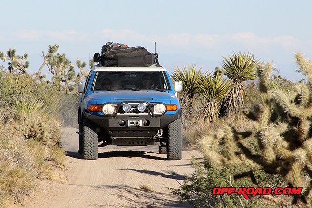
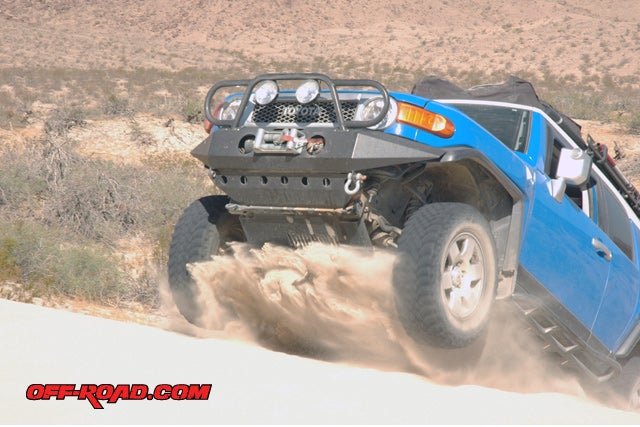
Josh Lipson in his Toyota FJ Cruiser travels on the Mojave Road
The Mojave Road—a trip that all off-road enthusiast must do during their life. It’s one of the most scenic, historical and at times--challenging dirt road trips in the west. It’s up there with adventure treks to Moab and Baja. There’s always something new to be discovered just around the corner.
Why is this place so special? Well…there’s a great deal of history dating back to when Native Americans roamed the Mojave Desert. The Mojave Indians would use this road for trading with tribes on the Pacific coast. This route was later introduced to early European explorers, The Missionaries, and finally the early California settlers looking for a safe way to go out west.
The Mojave Road spans 132 miles—from the Colorado River out west to Afton Canyon, just outside of Baker, CA. There are a number of natural water springs that made passage through the desolate desert possible. The steady supply of water from the springs would ensure safe travels.
With peak temperatures reaching well over 115-degrees Fahrenheit in the Mojave Desert—water was key to making the trip out west for early explorers and settlers of California following the Mexican-American War (1846-1848).
Today much of the original wagon trail remains open, with off-road access through the Mojave National Preserve and parts of Afton Canyon thanks to the efforts of The Friends of the Mojave Trail. In 1980, a project to restore the Cairns—rock piles marking the route—and documentation of historical landmarks began.
THE TRIP
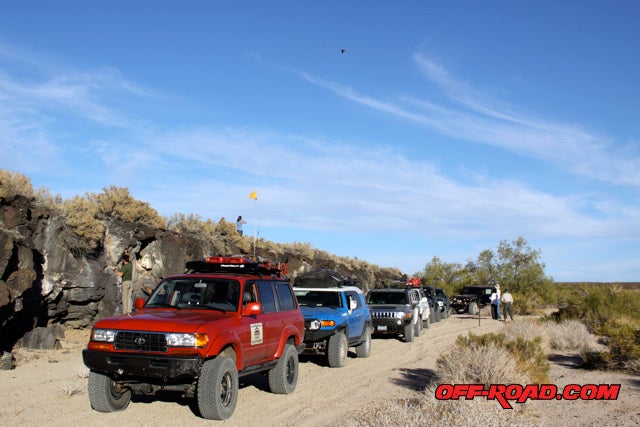
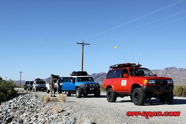 Tom Severin from Badlands Off-Road Aventures leads the group in his red Toyota Land Cruiser FZJ80
Since this would be our first Mojave Road trip, we tagged along with 4WD expert Tom Severin from Badlands Off-Road Adventures.
Tom has done this trip many times; he does it at least once a year with a group, many times students he has trained in his 4x4 driving school (www.4x4training.com). We took one of Tom’s Rock Crawling Clinics in Johnson Valley and were very impressed with both his program and persona. It was in great part why we decided to go along on this 3-day, 132-mile off-road trip.
Tom is a former Deputy Wildlife Conservation Officer with over 40 years of 4WD experience. If that wasn’t enough, a long list of off-road certifications follows his professional background: International 4-Wheel Drive Trainers Association, Wilderness First Responder (WFR), CA4WDC 4WD instructor. So in other words, this guy knows his stuff.
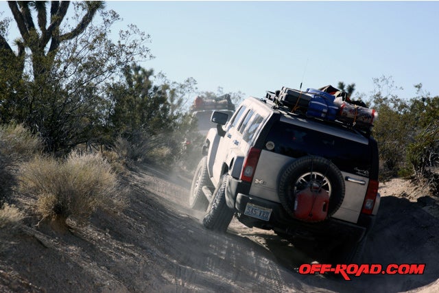
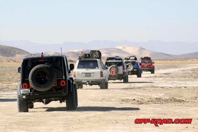
We met at the Avi Hotel & Casino on the banks of the Colorado River. From there the group of 7 vehicles consisting of Toyota Land Cruiser, Jeep Wrangler, Hummer H3, FJ Cruiser and Chevy Z71 set tires on the dirt across Fort Mojave.
MOJAVE ROAD: East to West – Day 1
Aired down, and fully loaded with enough supplies to last a week, we zeroed out the odometers and followed Tom on a 3-day off-road expedition. We traveled across HWY 95 into sandy, rocky terrain that allowed us to travel between 5-10 MPH. Our goal was to make it to Fort Piute at Mile 23 by noon.
Before the trip, Tom had sent an email with an itinerary and info. On that list was a book written by Dennis G. Casebier called Mojave Road Guide: An Adventure Through Time. This book gives a history of the region, the route, and documents each mile, including points of interest along the way. Having a copy and reading it before the trip will really make it more enjoyable. Tom helped make our trip colorful by narrating some of stories in the book and adding his personal experiences.
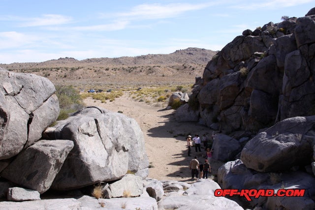
We often stopped to sightsee, which was a great way to get out and explore beyond the tracks of the road. This was not a race, not a competition with nature and our vehicle. We were re-living a part of history by traveling the same route so many had traveled before us.
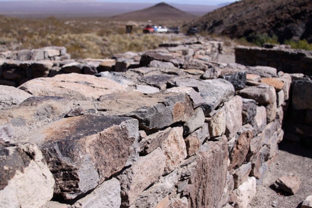
When we finally got to Fort Paiute we walked around and tried to envision what it might have been like. All that remains of the Fort are the foundations and a 4-foot section of the walls. Still, what little is left helps embody the life that U.S. soldiers had living in the middle of the Mojave desert, protecting travelers and being on the offense against hostile Indian tribes.
The group had lunch at Fort Piute, tailgate style. Everyone was responsible for his or her own supplies, and that included food preparation. Stoves, camping supplies, cookware and gadgets were part of the experience. There’s nothing like cooking food on an outdoor trip.
Jim & Becky Warnken driving their Hummer H3 up a deeply rutted trail on the Mojave Road
Tom’s plan was to travel about 50 miles on Day 1, in order to reach our camp before dark. So on we went on the Mojave Road.
THE MOJAVE ROAD
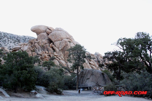
We continued driving on the Mojave Road, and the elevation started to rise above 2,000 feet—there were thousands of Joshua Trees surrounding us in every direction. We approached our campsite at the foot of scenic rock formations and spires.
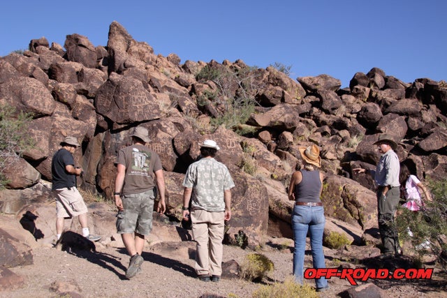
A side trip taken to Indian Well, where a mountain of prehistoric Indian art can be found.
We camped at Carruthers Canyons; a beautiful primitive campsite located about 5 miles north of the Mojave Road near mile 45 of the trail. The camp is surrounded by mountains rising over 7,500 ft, chaparral plant and piñon trees.
It had been a long day. We set-up camp, cooked dinner and built a fire. The day melted away.
MOJAVE ROAD: East to West – Day 2
Early breakfast and loaded by 8:30 am the group prepared for another long day of off-roading and adventure. The night had been cold, in the 30s at Carruthers Camp (elev. 4,460 ft.). The morning sun coming over the New York Mountains highlighted the granite hills above our camp--it was amazing.
Some of the early mining in the region took place around the Caruthers Canyons in the 1860s
Tom led the group out of the Carruthers Camp area and stopped to look at a rock house found near the intersection of Carruthers Canyon and the Mojave Road. The place looks like it’s abandoned, but apparently there are still owners for many of these parcels out here established back in the 1900s during the Homestead Act.
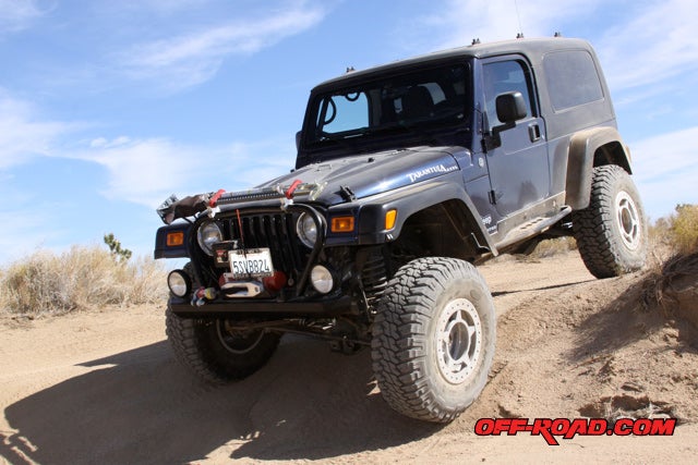
Paul Childers on the Mojave Road driving his Jeep "Tarantula"
We drove to about Mile 49 on the Mojave Road to reach a steep drop down into Watson Wash. The hill had a steep grade, low gears and power braking was a must. There were some off-camber ruts towards the bottom that made some of our group rigs get up on 3-wheels.
From there we headed to Rock Springs.
Rock Springs, Mojave Road
Camp Rock Springs is located near Round Valley, in the Mid Hills region of the Providence Mountains. The historical importance of this location in crossing the Mojave from east to west was the water found here. In 1866, an Army post was built called Camp Rock Springs. It was used until 1868, when the U.S. Mail was taken off the Mojave Road.
 In the hills above Rock Springs there still stands a rock structure built by World War I veteran Bert G. Smith. Today it is preserved and owned by the National Park Service (NPS). It has been around since the 1930s.
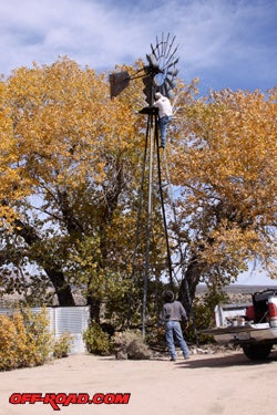
Day two of the trip took us through some old cattle farms in Round Valley area. Cattle farming has been part of this region for over 100-years. We stopped at the Government Holes were cattle companies once got water for their herds. Today, cattle farming in this region is becoming less and less because the National Parks Service doesn’t like cattle grazing in the Mojave National Preserve.
During our stop at Government Holes we met some Cowboys. They were busy trying to get the water windmill fixed so it would start pumping water at Government Holes once again. I’m glad there’s still people that care about preserving important pieces of history.
 SIDE TRIP – KELSO TRAIN DEPOT
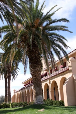
Although this was an Off-Road trip, we couldn’t pass on visiting the little town of Kelso. It once was a thriving place where the Union Pacific had a station known as a “Club House”. In order to get trains from Arizona over the pass into Los Angeles—helper engines at Kelso would push the train up the hill.
Today the Kelso Train Depot has been repurposed as the Visitor Center for the Mojave National Preserve. Its beautiful Spanish architecture fills the blue desert skies. Inside the building houses a museum, gift shop, and one can even eat at the original Beanery. Talk about a blast to the past.
I highly recommend you making Kelso part of your Mojave Road adventure.
Back on the dirt road, we made our way to Marl Springs at mile 70.4. This spring is thought to be one of the most important springs heading west, since from this point the Mojave Road starts descending into the more barren and hot parts of the desert known as Devils Playground.
The next water source west of Devils Playground is at Soda Springs—about 30 miles away.
THE MAILBOX
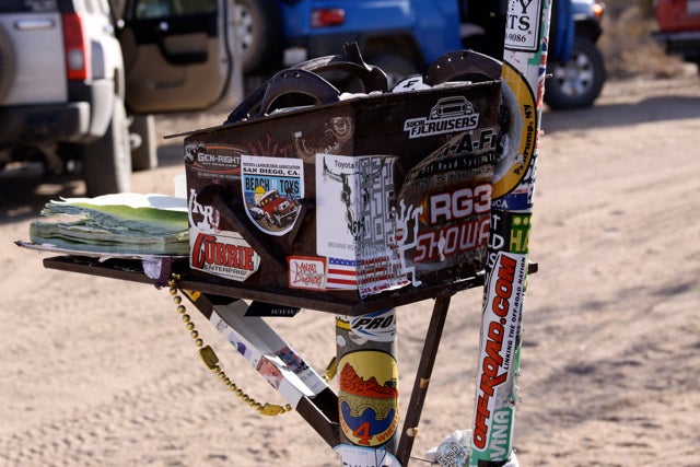
The Friends of the Mojave Road placed a mailbox along the Mojave Road at Mile 73.8 back in 1983. There is a book inside the mailbox that passersby are encouraged to sign and comment in. The Friends of The Mojave Road use this information to help update future Mojave Road Guides. It’s also a fun right of passage to be part of hundreds of others that have enjoyed this amazing road.
Just a stone’s throw away from the mailbox, visitors have started a Frog Shrine. There are different size and shapes of frogs congregated in the middle of the Mojave Desert. It’s an interesting exhibit. Too bad my wife didn’t come on the trip with me—she loves frogs. Now I have a reason to come back again—bring my girls to see the Mojave Desert Frogs.
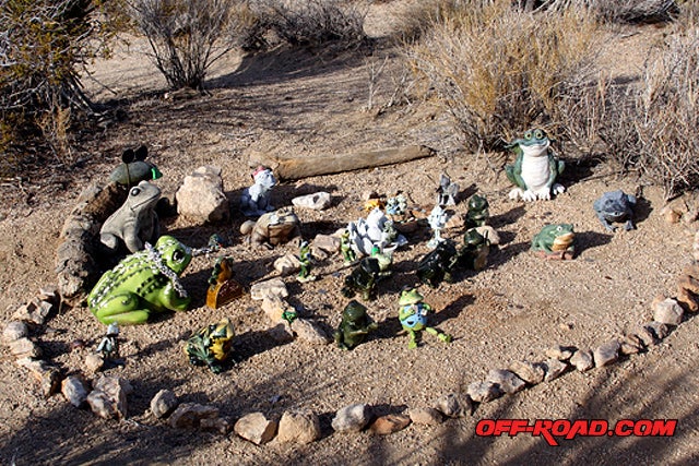
Frog Shrine – Mojave Road, CA
The day was getting late and the sun was setting in the west. We were about 15 miles away from our campsire at Seventeen Mile Point. Along the route were the Lava Beds, where a sea of lava flow is frozen in time. The lava towered us at around 20ft.
Camp at Seventeen Mile Point was a big change from Carruthers Canyons the night before. We were now at an elevation of 1960 ft., so the temperature was much warmer. At night, it was in the 70s and windy. Lucky for us there was a big rock ridge to south of us that acted like a wind barrier.
The last night of camping resulted in a large campfire followed by delicious food cooked slowly over the fire. The starry night blanketing the desert floor was inviting. It was a beautiful sight sleeping under the Mojave Desert sky. Life is good.
MOJAVE ROAD: East to West – Day 3
The last day of our 3-day Mojave Desert trek was exciting. We had about 10 miles before hitting the vast Soda Lake that might or might not be passable. The muddy lake can be very sticky at times, enough to suck in your mud boggers.
To make sure our entire team didn’t get stuck, we spaced out during the crossing. Luckily there hasn’t been much rain this year, so the lake was for the most part dry and packed. We stayed on a marked path across Soda Lake towards Travelers Monument, between Mile 100 and 101.
It’s tradition that passersby re-locate a rock from the eastern Mojave to this point to commemorate their journey and that of others before them. We followed in tradition and took a group photo to document the moment.
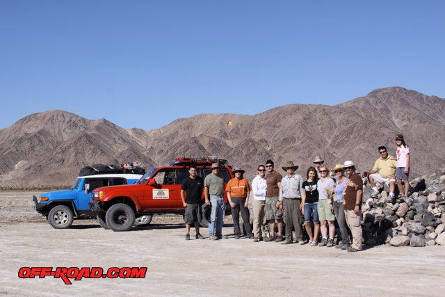
Travelers Monument: From left to right--Jaime, The Lipson's, Tom Severin, Paul, the Ange'ls and Warnken families...don't forget Teddy the desert dog
From this point Tom Severin led us towards Afton Canyon. On the way there we came across some sand dunes at mile 102. The soft sand required 4WD. We played a little in the sand, going up and down the dunes.
Josh Lipson playing in the sand at Rasor OHV Area in his FJ Cruiser (Photo: Stephen Lipson)
Following the Mojave River Floodplain we approached the Rasor OHV Area at mile 114.
Afton Canyon is a great place to visit on its own. There are many little side trips to take to see things like old mining caves, old lime mills, amazing rock wind formations, buried railroad cars and more.
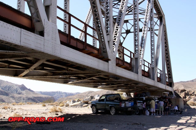
We stopped for lunch under the shad of the Mojave River train bridge
Our adventure was almost over. We crossed the Mojave Rviver and exited Afton Canyon. The group parked in a dirt lot adjacent to I-15, about 20 miles north of Baker, CA. Tom recommended we check our vehicles and air up before heading back home.
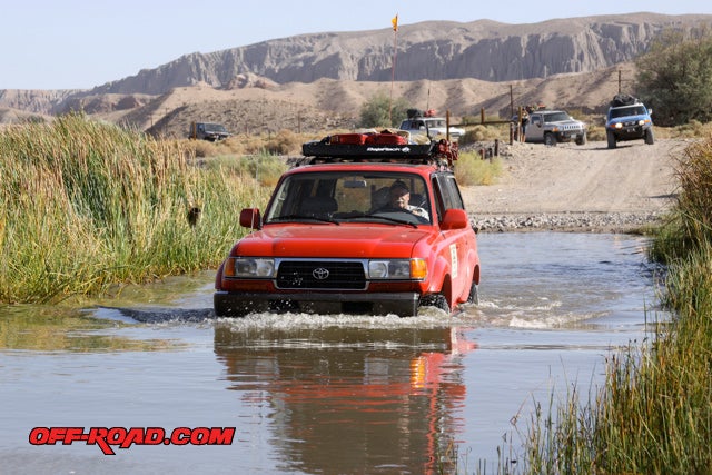
Mojave River Crossing on the Mojave Road
We had done it; we had completed the Mojave Road. There were no casualties, only a few small mechanical mishaps. The entire trip had transformed us all. We had met as complete strangers and become friends in the desert. Working as a team to get across the Mojave.
After our vehicle inspections, we all said our good-byes and it was back to San Diego, CA for me. It felt very weird driving on a freeway after driving on dirt roads for the last 3-days.
The trip was a milestone in my life. I feel very fortunate to have been able to live this experience. I couldn’t stop telling all my friends and family about all the adventures on the route. A true piece of history and something we need to keep open for future generations to experience.
Tom Severin from Badlands Off-Road Adventures was an excellent off-road guide. He was very knowledgeable about the region and survival. He also knows how to set up a good camp fire.
I would highly recommend looking up Badlands Off-Road Adventures if your planning on doing the Mojave Road or any other Off-Road Adventure trip in the west. Tom is a good guy to have in your group.
You can find more photos of our trip on My.Off-Road.com
Now go make plans for your off-road adventure!
SOURCES:
![]()
Badlands Off-Road Adventures
www.badlandsoffroadadventures.com
Friends of the Mojave Road
www.mdhca.org
Mojave Road Guide
By Dennis G. Casebier
www.mdhca.org/mdhcamrguide.html
National Parks Services
www.nps.gov/moja/planyourvisit/4-wheel-drive.htm
 Your Privacy Choices