Brought to you by Off-Road.com ©
Submitted by Randy Peterson
DUSY OHV ROUTE
KINGS RIVER DISTRICT SIERRA NATIONAL FOREST
NOTICE:
John Muir and Dinkey Lakes Wilderness boundaries begin on each side of the Dusy OHV Route, which is 300 feet from the center line of the route in both directions, or 600 feet wide, as posted by signs on the ground.
CAMPSITES:
Voyager Rock 3 miles 1/2 hourThompson Lake 11 miles 6 hours
Summit Lake 14 miles 7 hours
East Lake 17 miles 10 hours
Ershim Lake 22 miles 13 hours
Lakecamp Lake 26 miles 16 hours
Kaiser Pass 30 miles 2 to 3 days
(Distance from Courtright Reservoir in miles)
DIFFICULTY RATING:
MOST DIFFICULT . Recommended for advanced drivers. A route requiring a high degree of skill and challenge to travel. Not recommended for fill-size pickups, long wheel base vehicles or for traveling alone. Only short wheel base vehicles recommended beyond Voyager Rock Campground.DIRECTIONS TO ROUTE:
Follow the McKinley Grove Road east from Dinkey Creek for 13 miles, turning left at the intersection onto Courtright Road. (You may want to go on to Wish Reservoir to fill your gas tank before continuing.) Follow this road north for eight miles to Courtright Reservoir. Take the road to the right across the dam to the start of the Dusy OHV Route (Follow McKinley Grove Road to Courtright Road, turn left to Courtright Reservoir. Cross the dam to the east side of the lake and stay on the road to the Dusy-Ershim OHV Route sign).If you don't like the view down a 1,000 foot vertical drop-off into Helms Creek Canyon, keep your eyes on the road. The road will soon be on more favorable ground! As you turn away from Helms Canyon, take in the scenic view on your right - the headwaters of the North Fork Kings River, the majestic LeConte Divide, and the high country of the John Muir wilderness. The starting of the OHV trail is about 1/4 mile beyond this point. A trailhead facility with parking, toilets, hitching racks an a small commercial pack station has been constructed at this point.
THE OHV ROUTE:
The vehicle way parallels the east shore of Courtright Reservoir as it winds through the forest and crosses over a lot of open rock areas. The route is located here because granite is much more resistant to use than vegetate areas, an the steep slopes make the trail more challenging.You are now at 8,200 foot elevation and the dominant tree type becomes lodgepole pine as the red fir gives up its hold. Even in the open rocky areas lodgepoles exist, often growing from cracks in the rocks. This first mile of trail is shared with foot and horse traffic so please be considerate of these other users and give them time to get out of your way (The route begins at 8,400 feet elevation, with many open rocky areas. Be aware that portions of the trail cross large granite slabs and are marked with rocks. Elevation raises to 10,000 feet at Thompson Lake, remaining at the 9,00 to 10,000 foot range for most of the rest of the route).
The vehicle way veers uphill and to the left, away from the creek and across a large granite slab where the trail is marked by rock "ducks" to Voyager Rock Campground. Vehicle travel along the creek to Maxson Meadow is not permitted.
Voyager Rock campground is situated close to the shore of Courtright Lake with easy access for fishing. Fire grates and tables are available. Dogtooth and other peaks are to the west. A foot trail starts at the northwest end of the campground and follows the lake shore around the north end to Dusy and Helms Meadows.
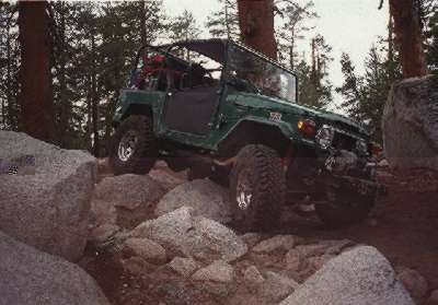
As you leave the campground, be sure to keep to the left. The road on the right, leading to Chamberlains' Camp, is a short road for official use only. Your road appears to dead- end at the base of a granite dome. What faces you is the infamous Chicken Rock. This rock has humbled many people, especially those with under powered vehicles. If your vehicle has adequate muscle, it `s no problem. The rock slope looks like it `s at a 50 degree angle - and it is. As you get closer to the top, panoramic views of Courtright Lake and surrounding preaks appear on your left. On your right is the huge monolith, called Maxson Dome.
The Sierra Nevada Mountains have been greatly altered by glaciation and erosion. Chicken Rock is what geologists call a "roches moutonnes" or a rounded rock left on a deserted glacial floor. As the glacier moved over the rock, it made the uphill side (the side you drove up) smooth and gradual, while the opposite side is more irregular and steep. You can actually see the marks left behind by these glaciers as debris they picked up gouged lines, or striations, into the granite.
Other nearby domes, like Maxson and Voyager Rock, were too large to be overridden by the glacial ice, but its passing did alter their shape, polishing and smoothing the massive rocks. After the ice receded, another process, called exfoliation, started working on them. This weathering "leafed away" layers of granite, similar to the way you peel onions.
As you drive along you will see large isolated boulders on a ridge or in a grassy field; these are called "erratic". These boulders are carried own the valley by the glacier and when the ice melted, they were deposited a great distance from their source.
From Chicken Rock you descend to and follow the lake shore to Dusy Meadows. Be careful on this stretch the many mud holes have been known to bury bikers and jeeps alike. The large creek you cross is Dusy Creek, one of three major tributaries that feed Courtright Reservoir. Here you'll find a few good campsites, but you'll probably want to wait until summer to camp as mosquitoes will carry you off if it is still marshy. Pleas do not drive in the meadows - they can be quickly destroyed by vehicles.
The road follows the meadows fringe for about three miles, crossing many small streams, before it drops into the woods heading toward Thompson Hill. Be forewarned that Thompson Hill is probably the nastiest stretch of road on any of the OHV routes in the Sierra National Forest. The ridge is at 10,000 foot elevation. Therefore the vehicle engines tend to "load up". It is a good idea to approach this section either in the early morning or late afternoon when it is cooler. Take your time, drive cautiously and you'll probably make it without any problems. "Old hands" figure 1- 1/2 miles per hour is top speed to negotiate this section safely (Thompson Hill is a very challenging stretch of road. Vehicles should have a body lift, run fairly cool and hit on all cylinders. Even tires with aggressive tire tread will benefit from reduced air pressure. Even with all of these precautions, several stops may be necessary to throw a few rocks in the right places for traction). Click here to see a picture taken on Thompson hill looking back at Courtright Resivoir.
When you reach the top of the ridge, you cross the dividing line separating the Pineridge and Kings River Ranger Districts. This point also separates the San Joaquin and Kings river watersheds. The remainder of the road is managed by the Pineridge District with headquarters at Shaver Lake. Thompson Lake, a short drive beyond the ridge top, offers several attractive campsites and a chance to test your fishing skills. For an example of what vehicles can do to meadows, look at the south end where visitors left their mark in 1980 (Vehicle access into Thompson Lake is close at the wilderness boundary. A camping site with room for a few vehicles an tents is available there. The walk to Thompson Lake from the campsite is short and easy. Another fishing spot, Lost Lake, is an easy 45 minute walk from Thompson Lake).
Continuing on the route, Summit Lake is about an hour from Thompson Lake. Summit Lake does not have a defined camping area, so please use care in choosing your campsite away from the meadow area.
The next campsite available is near East Lake. East Lake is not visible from the OHV route, making it easy to miss. From the campsite adjacent to the road, its only a short walk to the lake, fishing and an excellent photo spot with picturesque Dogtooth Peak in the background.
East of Black Peak the Dusy Trail connects with the Ershim OHV Trail, continuing on to Kaiser Pass. It stays around 9,000 to 10,000 foot elevation, passing several meadows and timber- lined lakes. A nice and very popular place to camp and fish is Ershim Lake, where local 4W clubs have built rustic facilities. Ershim Lake has lots of space for camping an parking. The route from the top of Thompson Hill to Ershim lake is fairly tame allowing the scenery to become more interesting than the challenge of the trail.
It takes about three hours to cover the four miles from Ershim Lake to Lakecamp Lake. Rainbow trout make Lakecamp Lake unique as the other lakes along this route have Brook trout. Another fishing spot, Mallard Lake, is an easy 20 minute walk from Lakecamp Lake.
The next four difficult miles to Whitebark Vista will test driving skills, but the panoramic views make it worth the effort. The route ends at Whitebark Vista. Many people prefer to use Whitebark Vista as a starting point. Huntington Lake is about 30 minutes away.
As you approach Kaiser Pass views are spectacular. White Bark Vista offers panoramic views of landscape around Edison and Huntington Lakes and of the crest of the Sierra Nevada Range.
CAMPING TIPS:
There is no camping within 100 feet of lakes, streams, trails an meadows. Campfire permits are free and available at your local forest service office. A campfire permit is require for: wood fires, charcoal fires or portable gas stoves.WILDERNESS PERMIT:
A Wilderness Visitor Permit is require for overnight trips into the John Muir or Dinkey Lakes Wilderness areas. A separate permit is required for each trip. Permits are free of charge. A PERMIT IS NOT REQUIRED FOR DAY USE OF WILDERNESS AREAS.The Dusy-Ershim OHV route forms the boundary between the Dinkey Lake wilderness and the John Muir Wilderness. It is a 600' wide OHV Route between two wildernesses. USE OF THE OHV ROUTE DOES NOT REQUIRE A WILDERNESS PERMIT. Day use of the wilderness does not require a permit. Overnight trips into a wilderness adjacent to the OHV route requires a permit.
For the John Muir Wilderness all trailheads require a reservation between July 1 and Labor day. Reservations may be made from March 1 thru August 15. Permits are require all year. For the Dinkey Lakes Wilderness permits are required all year, no reservations necessary. Contact:
Have a safe and pleasant stay in your National Forest !Pinerige Ranger District P. O. Box 300 Shaver Lake, CA 93664 (209) 841-3311
FOR OHV ROUTE INFORMATION CONTACT:
 Kings River Ranger District
 34849 Maxon Road
 Sanger, CA 93657
 (209) 855-8321

 Dinkey Ranger Station
 Dinkey Creek Road
 June thru mid-September
 (209) 841-3404
MAPS:
SIERRA NATIONAL FOREST MAPGood map to use to find the Dusy- Ershim OHV route (shows surrounding area).
DINKEY LAKES WILDERNESS MAP
Good map to use while traveling the Dusy-Ershim OHV route (shows the entire route).
Copyright © Off-Road.com, 1996 All Rights Reserved
|
Off-Road.com Newsletter Join our Weekly Newsletter to get the latest off-road news, reviews, events, and alerts! |
Follow @Off-Road
 Your Privacy Choices