Trail Riding - Heaven (Almost) in West Virginia
An Introduction to the Hatfield-McCoy Trails
We found out about the
Hatfield-McCoy Trail System through hearsay and rumor ? you know, the usual
route for precious information. After checking their web-site at www.trailsheaven.com,
a trip was immediately planned for Zack and I to investigate and see if all the
hype was true. (That was February. We had to wait a little while for
the snow to melt.)
I'm happy to report that it is. In this case, the government is involved and it's a good thing for us dirt bikers. Here's what it's all about.
The System
The Hatfield-McCoy Trails currently comprise 300 miles of dirt bike and ATV trails located in rural mountainous southwest West Virginia. The land provided for the trails is privately held, mostly by large absentee natural resource companies (read coal and timber). This system is expected to expand over the next few years to 2,000 miles of trails in seven counties. H-M is part of the White House Millennium Trails Initiative and is available for power sports enthusiasts (us), mountain bikers, equestrians, and hikers.
At his time, there are three riding areas developed:
- Dingess Rum Trail (really!) starting at the Bear Wallow Trailhead
- Buffalo Mountain Trail (Reverend Compton Trailhead),
- Browning Fork Trail. (Rockhouse Trailhead)
Kathy Mulholland, Hatfield-McCoy's Marketing Director told us there are plans to open an additional 100 to 200 more miles of trails in Boone and other counties this year. The project has been incubating since 1991 and the trails finally opened in October of 2000 after receiving support from the State of West Virginia, Army Corps of Engineers, and the Motorcycle Industry Council among others.
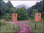
Housekeeping
User fees run $25 for an in-state year-long permit, $50 for out of state, and $25 for an out of state three day permit.
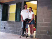
|
Friendly help at the Dinguss Rum trailhead |
Off trail riding is not permitted. All riders must wear helmets and eye protection. Only one rider per bike/atv is permitted.
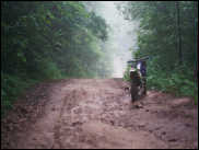
The Terrain
If you haven't visited West Virginia, or skipped sixth grade geography, you might be surprised at what you'll find. Southwestern West Virginia is extremely mountainous. Mining has been the major activity there for over 100 years, not to mention the odd feud now and then. Most of the mining has been strip mining the coal out of the slopes of the mountains with some horizontal shaft mines too. Elevation changes from around 1,000 to 2,500 feet and there is a LOT of up and down to contend with. Most of the rock is sandstone, shale, coal, and others we couldn't identify. It seems though, that mud ? the deep down and boggy type, isn't in good supply. That can be a good thing.
What seems unusual when comparing the mountains of H-M with other mountainous areas in the USA is that these are so darn close together. If you've ever heard the saying "we have to carry the sunlight into this holler in a wheelbarrow." it was written about the Hatfield-McCoy area! The towns in the area are built out right to the sides and sometimes going up the sides of the mountains. The city streets of Logan have a European feel in their narrowness.
Because coal has been the economic driving force, there have been countless haul roads cut into the hills to get it out. These roads have made the basis for the trail system. The long decline in coal mining has also made the development of a semi-non-politically correct thing like off-road trail development seem downright respectable.
The Trail System-System
This is an easy one if you've ever alpine skied. All trails are marked as to their difficulty rating. Green means easiest, Blue means more difficult, and Black means most difficult. There is some variation in the ratings. We rode green trails that were like streets without pavement, and rode other greens that seemed like blue (more difficult) trails. Some of the Black trails we saw but didn't ride (cluck cluck) looked like they should satisfy the most determined masochists. The trail rating system is surely subjective and so are our opinions.
 |
As a way of calibration, we created the "Spode Scale". The Spode Scale goes from of zero to ten with zero being pavement, any pavement, and ten being European Indoor Trials stuff. We rated the green trails as one to three with peaks as high as four. Some of the black trails would go into the six to seven range.
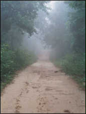
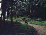
Riding Conditions
Most of the mountains are covered with vegetation, oaks, hickories, beech, and all the usual undergrowth. This is literally cool as the trails are frequently shaded in a 30-foot high canopy of leaves. For the more wide open trails this is a boon. However, once you get off the popular trails and into the more difficult areas, it can be a hassle as now you can get smacked in the face every few yards with another wet tree branch!
Trail conditions varied from gravel, to rock, to sand to hard packed clay. Of course all combinations of the above were available if you traveled far enough. We tended to stick to the main trail-ways to get the largest picture of what the area was like. Because of that, we didn't get to try as many of the side trails.
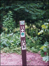
|
In the misty morning on trail 16 |
Most of the trails we rode consisted of side mountain traverses continually going either up or down hill at a moderate rate. Trail width varies from single track to jeep trail width. Nearly all of the trails are wide enough for an ATV except for the designated single-track runs.
One trail we rode several times due to it's fun nature, excellent traction, good scenery, and opportunity for moderate speed playing was trail 16 in the Dingess Rum Trail system. Here's how it went.
|
Ridge top trail ? 500 feet down ten feet of either side |
Starting at the trailhead you wind though ? mile of old overgrown gravel haul road. Once the trail turns right you start a long hillside-traversing climb to the top of the mountain. This section is probably 2 miles long and is a great second and third gear blast, with some small bumps to wheely and bounce over, and enough rocks and ruts to keep you focused. Once at the top the trail runs the top of the ridge for another two to three miles over sandy/clayey soil with some bedrock. There is also a new type of soil there I plan to submit to the USA Department of Dirt for further investigation. (See side bar) The trail then goes back down hill along another gentle but fun slope to the blasting area where some mining is continuing. (Don't go into the basting area!) At this point we turned around and rewound the whole trail just for fun. Going quickly, it took us about 45 minutes to complete this little trail round trip with no breaks.
|
Zack (Aquaman) checks the view ? Rev. Comption |
We missed the opportunity to ride from the Rev. Compton trailhead into Matewan due to a little rain and butt soreness. We're sorry because this is the one town that will let you ride into town on your unlicensed dirt bike for gas and food. Were told it was a good 20-mile ride and a nice middling difficulty trail.
One last note: Pack some water along for a summer time ride. It can get hot if you stay out long. Our tongues were hanging out after a couple of hours riding in the 90-degree humidity.
Is It Crowded?
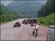
|
We found while riding on a Thursday and Friday in June we practically had both the Dingess Rum Trail and the Buffalo Mountain Trails to ourselves. Rockhouse was closed during our visit due to logging. We had to leave early on Saturday and it looked like the parking lot at Dingess Rum Trail was going to get some significant use. The trail checkers told us they expected to see 50 to 60 riders there on Saturday. Overall, the Hatfield-McCoy Trail system is selling about 125 user permits per week so crowding just isn't an issue yet.
Our informal parking lot survey produced the following minimal statistics:
- 80% of trail riders are riding ATV's (come on, dirt bikers!)
- We saw only Ohio, Pennsylvania, Kentucky, and West Virginia license plates at the trailheads.
The Future?
The story here seems to be dependant on how popular the trails become. The Hatfield-McCoy trail Authority believes that the more the trails are used, the more permits are sold, the more hotel rooms are rented and restaurants patronized, then the more local and statewide support there will be for the system. West Virginia has already had one good experience with tourism promotion in the white water tours and supporting businesses serving the New River and Gauley River white water runs. They hope to accomplish the same this with the trails.
Their goal is to get to 800 permits sold per week so there's a long way to go from the 125 or so at this time.
So, in a way, it's up to us. If we use these trails they'll get bigger and better. But, without growth, it's hard to imagine H-M growing quickly on government inertia alone.
|
What's Not To Like?
Not much. Hatfield-McCoy is not nearly as developed as for example the Moab area. There are limited attractions to enjoy for your soul mate/significant other that doesn't ride. There are a few motels and campgounds, but the area is just now waking up to the opportunity to have tourists contribute to the local economy ? you know ? fleece them!
Example: No one was selling firewood in 20 lb bundles for five dollars each. I'll bet that next year when we go, someone will have figured it out. Check out the H-M website for links and local contact information on hotels, campgrounds, etc.
We were told by a few that some of the local fellows didn't like now having to pay for something they had grown up doing for free. That they didn't like being told to wear helmets and not get drunk while riding or stay only on the marked trails. This has supposedly caused some friction with the Hatfield-McCoy Trail Authority's efforts to expand the trails and maintain safe conditions. We didn't see any evidence of this.
|
Actually, it was very refreshing to visit an area for fun, and when I left I didn't feel as if every hand in town had been in my pocket. Everyone we met was glad we were there, hoped we would enjoy our visit, and helpful almost to a fault. Nice.
We know we're going back to Hatfield-McCoy to ride some more, we just have to figure out when. I hope to see you there.
Special Thankie's and other Kudo's
- Jeff at Fredette Racing for the radiator delivery on-time!
- Brady (the MAN) and the Four Way Store in Ethel, West Virginia
- Kathy Mulholland at www.trailsheaven.com for her time and information.
- Mike and his Dad from Chicago for being good guys.
The Right (Mud) Stuff (Sidebar story)
Friday, we got caught in a driving rainstorm about as far from the trailhead as we could get. (Hey, you can't always believe the weatherman if he says it's going to rain!) While running the ridge top section of trail 16 I discovered a new form of mud.
Being from northwestern Pennsylvania (40+ inches of water per year), I consider myself something of an expert on mud. We have a plethora of mud types in abundance and especially the very deep kind that swallows boots, socks, bikes and anything you can drop at the worst time. We ride lots of mud in all months of the year except when there is snow and ice to ride. "Slick R Us" you could say.
Anyway, while running back to the camp, at about 20 miles per on an off-camber ridge top straight, the bike started a slow slide to the right that eventually turned into a super slow motion low-side. When I tried to get up I found it was impossible to stand on this yellow-greenish hard baked mud with a 2-millimeter layer of zero traction sloppy on top!
Finally, I had to crawl off the trail into the grass on all fours to find enough footing to stand and grab the KDX by the bars and drag it over into the grass to remount.
Once upright and rolling (sort of), I knew to avoid the dreaded yellow peril, and finally made it back to camp soaked to the skin. Zack, of course, was waiting for me there commenting on "old and slow".
|
Off-Road.com Newsletter Join our Weekly Newsletter to get the latest off-road news, reviews, events, and alerts! |
Follow @Off-Road
 Your Privacy Choices