 Santa Clara, CA – Magellan recently unveiled its new off-road vehicle navigation solution, the eXplorist TRX7, for the 4×4 and Powersports vehicle consumer markets at the AIMExpo in Orlando, Florida. Designed specifically for the off-roading enthusiast, this navigation device offers improved driver safety, a superior user experience including detailed 3D maps and community generated trail data, all at an exceptional value right out of the box.
The eXplorist TRX7 allows users to plan, track and save trail rides and add pictures and comments to share with friends, family, or the larger off-road and outdoor communities.
“Magellan’s new eXplorist TRX7 is the most fully-loaded, affordable and purpose-built off-road navigator for adventuring,” commented Stig Pedersen, associate vice president of product management for Magellan. “Whether you want to navigate the classic trails, or want to create your own adventures, the Magellan eXplorist TRX7 stands ready to help you traverse some of the most rugged terrain.”
The Device
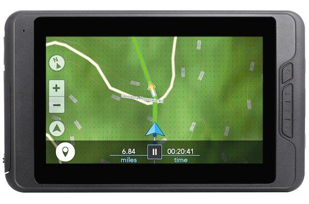
The Magellan eXplorist TRX7 features a weatherproof 7” LCD touchscreen display, along with Wi-Fi and Bluetooth connectivity. Meeting IP67 standards, this ruggedized device is water and dust proof. It comes with a Marine-grade pogo-pin mount and Genuine RAM® Rail Mount, ideal for 4×4 vehicles as well as ATV, UTV and side-by-sides.
The eXplorist TRX7 packs a lot of maps, trails and POI’s on board. Magellan designed the TRX7 with a powerful Dual Core Cortex-A9 processor, and 1G Mobile DDR2 memory, running on Android™ 4.2, to ensure a fast and smooth off-road navigation experience. In addition, with 16GB onboard memory and a 64GB MicroSD card expansion slot, TRX7 has the storage to accommodate new outdoor maps as they are developed.
The Maps
The device comes preloaded with over 44,000 trails, making it the most comprehensive outdoor trail maps available for off-road enthusiasts.
Magellan’s detailed off-road maps feature:
· High resolution 3D Terrain
· 2D Topo base map & contour elevation lines
· National and State Parks and Recreational Vehicle Areas
· National and State service roads and trails
· Ever expanding crowd-sourced Trails
· Food, Gas, Lodging, and General Service POIs
· 3rd Party Trail Guides
The Magellan off-road vehicle platform’s trail maps are cloud based, dynamic, and will continue to grow and be improved by both Magellan and through crowd-sourced additions from the TRX7 user community.
Share the Ultimate Off-Road Experience
Outdoor enthusiasts have incredible stories to save and share. The Magellan TRX7 gives off-roaders, campers, and anyone enjoying the outdoors on a vehicle the tools to plan, experience, and capture their activities in a story format that they can keep or share. With seamless integration to social media sites such as Twitter, users are able to post their greatest trail adventures. The device also provides users with an online trip-planning and trail-sharing site. Members of Magellan’s dedicated off-road vehicle online community earn achievement badges for posting and sharing “dirt miles” traveled and total number of trails posted.
Improved Off-Road Safety
Users can confidently plan safe and fun trail rides by filtering trails on multiple criteria including: Difficulty, Length (Dirt Miles), Duration, Terrain, Technical Obstacles, and Awesomeness. Additionally, save important waypoints to trail rides, such as campsites, aid stations, and water, so users can easily navigate to those locations. TRX7 users know they will never be lost with Magellan’s Backtrack feature. The TRX7 automatically marks the location of the beginning of a trail ride, and with one touch safely navigates back to the starting point.
Availability and Pricing
The Magellan eXplorist TRX7 will be available in October with an MSRP of $599.99. Additional information about Magellan’s navigation products is available at www.magellangps.com.